Highlight: January–April 2024 publications using OpenTopography datasets
by Emily Zawacki
OpenTopography periodically highlights new research results that demonstrate the use and reuse of data from OpenTopography. These three publications highlight topographic research applications in earthquake hazards, wildlife and conservation, and geomorphology.
Using lidar to assess building damage after earthquakes
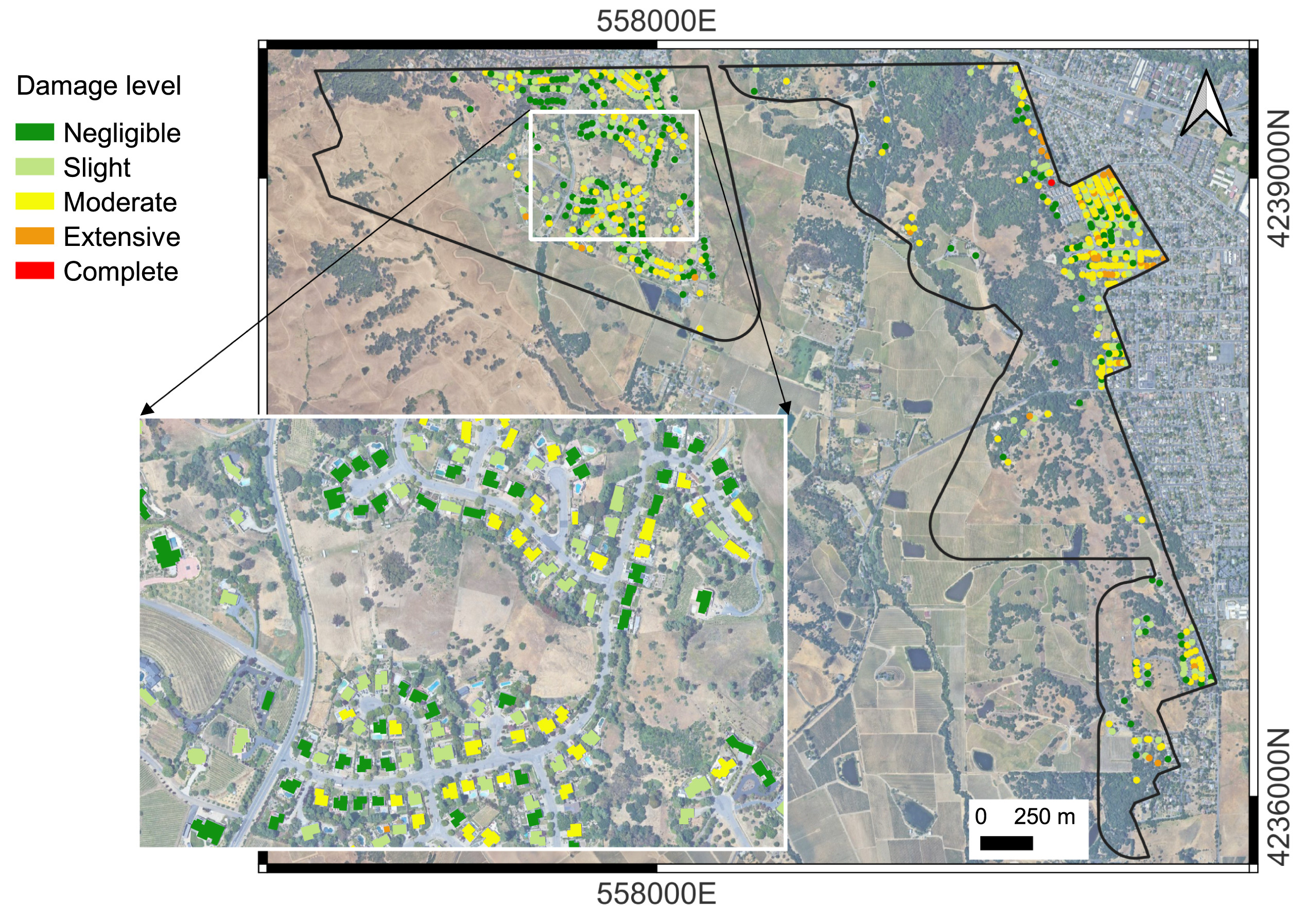
Determining if and how much buildings were damaged during an earthquake is crucial for emergency response and recovery. Remote sensing techniques provide an efficient way to detect damaged buildings. However, some methods can only distinguish between severely damaged and undamaged buildings, and not moderately damaged buildings. Foroughnia et al. used lidar data collected before and after the August 2014 magnitude 6.0 Napa, California earthquake to assess the degree of building damage at a new level of detail. Using 3D differencing techniques, the authors determined the horizontal and vertical displacements of the ground and buildings by comparing the pre-event lidar to the post-event lidar. The authors classified building damage from slight to complete using a structural engineering parameter, the “drift ratio,” that quantifies how much the building’s roof shifted compared to the building height. Their lidar-derived classifications showed good agreement relative to field inspections after the earthquake that tagged damaged buildings. The results demonstrate that lidar data and structural analysis can aid in post-earthquake response by detecting how much a building was damaged.
- Data used: August 24, 2014 South Napa Earthquake
- Publication: Foroughnia, F., Macchiarulo, V., Berg, L., DeJong, M., Milillo, P., Hudnut, K. W., Gavin, K., & Giardina, G. (2024). Quantitative assessment of earthquake-induced building damage at regional scale using LiDAR data. International Journal of Disaster Risk Reduction, 104403. https://doi.org/10.1016/j.ijdrr.2024.104403

Map of lidar-derived building damage assessment following the 2014 Napa, CA earthquake, colored by the degree of damage.
Habitat suitability and expansion for the common chameleon
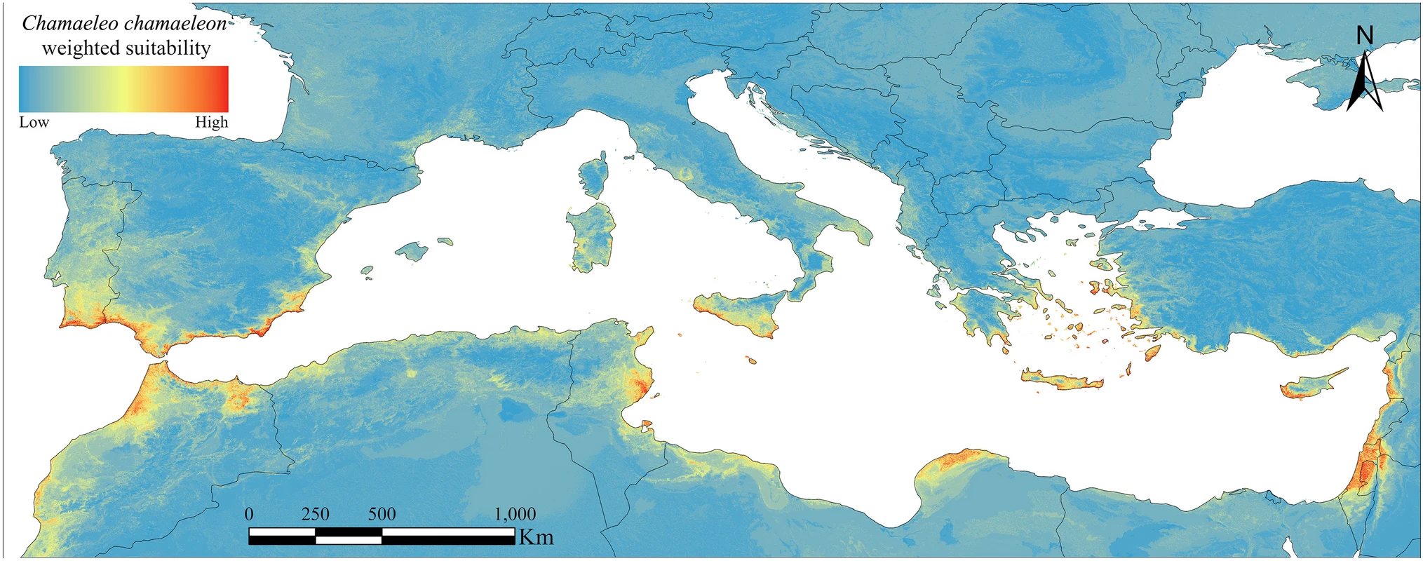
Reptiles have historically been introduced outside of their native range due to human trade and activities, and as a non-native species they can pose a threat to local ecosystems. The common chameleon, native to North Africa and the Middle East, was historically introduced to the Iberian Peninsula and Italy where it has become successfully established. Serva et al. evaluated the ecological requirements of the common chameleon in the Mediterranean basin to determine its most suitable habitats and possible expansion trends. They assessed habitat suitability based on climatic, topographic, and habitat-related variables under current and future scenarios. The common chameleon showed a habitat preference, for urban, shrubland, and cropland categorized areas at low-lying coastal elevations. Under future climate scenarios, the authors found a latitudinal change in habitat suitability for the common chameleon, with the eastern Mediterranean decreasing in suitability, and suitable areas in the Iberian Peninsula shifting westward. Such modeled changes are consistent with the cold-blooded nature of reptiles that make them particularly vulnerable to climate change. Given the common chameleon’s presence in urban and cultivated environments, the species may be additionally susceptible to anthropogenic threats. Understanding the ecological and expansion dynamics of the common chameleon will aid in future conservation efforts for the species.
- Data used: Copernicus Global Digital Elevation Models
- Publication: Serva, D., Cittadino, V., Bernabò, I., Biondi, M., & Iannella, M. (2024). Habitat suitability and connectivity modelling predict a latitudinal-driven expansion in the Mediterranean basin for a historically introduced reptile. European Journal of Wildlife Research, 70(2), 1-12. https://doi.org//10.1007/s10344-024-01780-9
 |
 |
Modeled habitat suitability for the common chameleon (left, photo: Benny Trapp), showing high suitability along coastal areas of the Mediterranean Basin.
Calculating the migration of watershed boundaries with high resolution topography
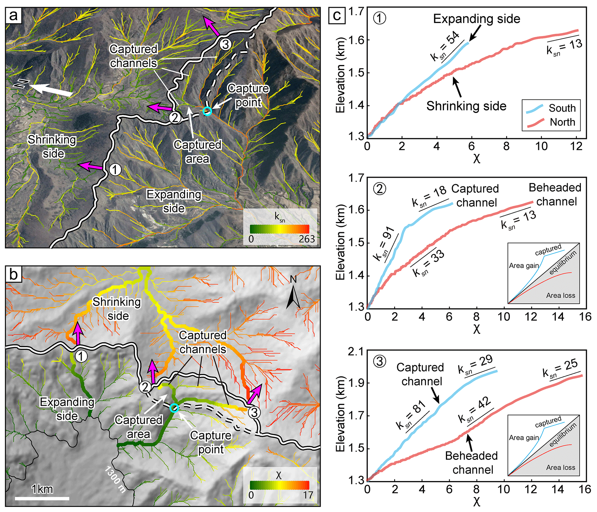
Drainage divides are the delineating boundaries between individual river basins, or watersheds, controlling where water routes and flows. Drainage divides do not stay in the same place, rather they move over time based on differences in the erosion rate and topographic slope between two watersheds. Divide migration can also cause parts of a river to be ‘captured,’ diverting and moving the river from one watershed to another. Zhou et al. proposed a new method for measuring how fast drainage divides move, or migrate, using high resolution topography. The authors created digital elevation models using Structure from Motion (SfM) photogrammetry over their two study areas in China based on uncrewed aerial vehicle (UAV) or drone data they collected. They focused on a watershed divide in an active rift and a second watershed in a tectonically stable area. They used the high resolution DEMs to determine the location and characteristics of the channel heads, which are the upstream most point where a river begins to flow and the closest part of the river to the divide. Based on this analysis the authors found that the drainage divide was moving northwestward in the active rift area, while the drainage divide was essentially not moving in the tectonically stable area. Their results highlight how the stability of drainage divides can be more accurately determined using high resolution topography, an important component in understanding controls on landscape evolution.
The data used in this study were submitted to the OpenTopography Community Dataspace for publication.
- Data used: High Resolution Topography of Wutai Shan and Yingwang Shan, China, 2021 (Community Dataspace)
- Publication: Zhou, C., Tan, X., Liu, Y., & Shi, F. (2024). Quantifying the migration rate of drainage divides from high-resolution topographic data. Earth Surface Dynamics, 12(2), 433-448. https://doi.org/10.5194/esurf-12-433-2024

Perspective and map view of one of the studied drainage divides in an active rift shoulder showing the direction it is migrating.
OpenTopography is supported by the U.S. National Science Foundation and facilitates access to topographic data for Earth and other scientific research and education. We closely track peer-reviewed publications that use OpenTopography data and services as they are an important measure of our impact.
Have a new paper out that uses data or services provided by OpenTopography and want us to highlight it in a future blog post? Drop us a note: info@opentopography.org
