Getting Started
1. What is OpenTopography?
OpenTopography provides web and API based access to high-resolution topographic data (meter to sub-meter) and regional to global datasets (1–500 m) derived from lidar, radar, and photogrammetry, together with on-demand processing and visualization tools that support research to advance our understanding of the Earth’s surface, vegetation, and built environment.
Quick Overview Video
2. What data are available from OpenTopography?
High Resolution Topography Datasets (sub-meter to meter resolution)
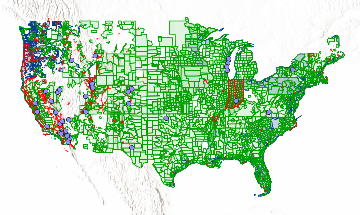
- OpenTopography hosted lidar datasets (red outlines on data map)
- USGS 3D Elevation Program (3DEP) (green outlines)
- NOAA Coastal Topographic Lidar (blue outlines)
- Community contributed data (purple outlines)
Regional and Global Datasets (1-500 meter resolution)
- Global Digital Elevation Models (e.g. Copernicus, ALOS, SRTM, NASADEM)
- PGC ArcticDEM and Reference Elevation Model of Antarctica (REMA)
- USGS 1 meter, 1 arc-second, 1/3rd arc-second Digital Elevation Models
- International Digital Elevation Model datasets (e.g. High and Medium Resolution Digital Elevation Models of Canada)
Discover and access the complete list of topography datasets via the Find Topography Data map interface.
View a listing of available topography datasets available along with detailed metadata information.
3. Are there any data access restrictions?
OpenTopography is funded by the Division of Earth Sciences at the US National Science Foundation to support academic Earth science research and education community*. OpenTopography provides many topography datasets freely to the public. However, some value-added datasets** such as USGS 3DEP, NOAA Coastal Lidar, ArcticDEM, and REMA are only freely open to the U.S. academic research and education community due to funding limits. Non-academic users can access these data by signing up for a OpenTopography Plus (OT+) subscription.
| Guest User | Registered User (non-academic) | OT+ Subscriber | Academics | |
| Data Access** | Limited: OT-hosted high resolution (red), global 10m+ (orange) | Limited: OT-hosted high resolution (red), global 10m+ (orange) | All datasets | All datasets |
| Point Cloud Selection (per job) | 50 million pts | 250 million | 350 million pts (250 Million for USGS/NOAA) | 350 million pts (250 Million for USGS/NOAA) |
| One-Demand Processing Tools | Limited | All | All | All |
| API Data Access | None | All Global (30m), USGS 10m & 30m | All Global (30m) & All USGS (inc. 1m) | All Global (30m) & All USGS (inc. 1m) |
| API Processing Limits | N/A | Global: 50 jobs/24 hours, USGS 10m & 30m: 50 Jobs/24 hours | Global: 200 jobs/24 hours, USGS: 200 Jobs/24 hours | Global: 200 jobs/24 hours, USGS: 200 Jobs/24 hours |
| Cost | Free | Free | OT+ Subscription $30/month or $330/year |
Free (create OT account with .edu email or via application |
* US academics with a .edu email, create an account and enable access to restricted datasets. K-12 teachers, international academics, and informal educators can apply for access here.
** Several restricted datasets are also available Open and Free to the public from other sources.
- USGS 3DEP - https://registry.opendata.aws/usgs-lidar/
- NOAA Coastal Lidar - https://registry.opendata.aws/noaa-coastal-lidar/
- PGC ArcticDEM/REMA - https://www.pgc.umn.edu/data/