United States Interagency Elevation Inventory
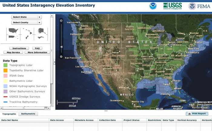
A common question we receive at OpenTopography is "do you know if there is lidar available for location xxx?". Typically, when we get this question I refer people to the OpenTopography Find Data page (an increasingly rich source for lidar data) and this page of links to online sources of lidar. But, there are large amounts of data collected by federal, state, and local agencies that can be hard to track down. Earlier this year, NOAA and the USGS, in collaboration with FEMA, released the United States Interagency Elevation Inventory which is meant to be a clearinghouse for "high-accuracy topographic and bathymetric data for the United States and its territories". The site does not host data, but it provides metadata and links to dataset sources. As you can see from the screen-cap, there is an impressive amount of high-resolution topography data available if you know where to look:

The elevation inventory was completed in May 2012, and will be updated annually. Although relatively comprehensive, it is not complete, and it currently lacks many datasets collected for the academic community by NCALM and available through OpenTopography. It is also worth noting that the data shown in the Elevation Inventory are highly variable in terms of resolution, quality, data products available, coordinate systems, metadata, etc. Remember, all lidar are not created equal. Regardless, the site is a great resource for anyone trying to determine if there is data available for their location of interest, and goes a long way towards making it easier to locate datasets collected by federal, state and local agencies.
More details from the US Interagency Elevation Inventory site:
The U.S. Interagency Elevation Inventory displays high-accuracy topographic and bathymetric data for the United States and its territories. The project is a collaborative effort between NOAA and the U.S. Geological Survey, with contributions from the Federal Emergency Management Agency.
This resource is a comprehensive, nationwide listing of known high-accuracy topographic data, including lidar and IfSAR, and bathymetric data, including NOAA hydrographic surveys, multibeam data, and bathymetric lidar. This inventory was completed May 2012 and will be updated annually.
The information provided for each elevation dataset includes many attributes such as vertical accuracy, point spacing, and date of collection. A direct link to access the data or information about the contact organization is also available through the inventory.
