Indiana 2011 - 2013 Statewide Lidar Survey Data Available
OpenTopography is pleased to announce the release of almost 50,000 square kilometers of point cloud and raster data covering the state of Indiana. The recently released Indiana 2011-2013 Statewide Lidar represents a joint effort to make statewide data available by several Indiana state and federal agencies as well as private companies and individuals through a service agreement with OpenTopography. The robust cyberinfrastructure and user-friendly interface of OpenTopography provide a one stop shop for the statewide survey data catering to a variety of users requiring a range of lidar topography data products, on-demand data processing and data analysis.
OpenTopography Features
This dataset features a new addition to the workflow that allows the user to specify a different coordinate system for their output data, which is done on the fly once the job is submitted. The three selected coordinate reference systems for this dataset are Indiana State Plane East (feet), Indiana State Plane West (feet) and NAD83 UTM zone 16N (meters). The data were delivered in Indiana State Plane East and Indiana State Plane West, which bisects the state and is often used in local and state government GIS work.

Modified steps in the point cloud workflow to accommodate multiple projections for 2011-2013 Indiana Statewide Lidar dataset.
Data
The complete Indiana statewide lidar survey includes three phases collected in 2011, 2012 and 2013. Point cloud and pre-generated raster data collected in 2011 and 2012 are currently deliverable through OpenTopography covering an area of 49,790 square kilometers (19,224 square miles), or more than half the state of Indiana! The 2011 and 2012 data available through OpenTopography includes central and eastern Indiana counties: St. Joseph, Elkhart, Starke, Marshall, Kosciusko, Pulaski, Fulton, Cass, Miami, Wabash, Carroll, Howard, Clinton, Tipton, Boone, Hendricks, Marion, Morgan, Johnson, Monroe, Brown, Bartholomew, Lawrence, Jackson, Orange, Washington, Crawford, Harrison, LaGrange, Steuben, Noble, DeKalb, Whitley, Allen, Huntington, Wells, Adams, Grant, Blackford, Jay, Hamilton, Madison, Delaware, Randolph, Hancock, Henry, Wayne, Shelby, Rush, Fayette, Union, Decatur, Franklin, Jennings, Ripley, Dearborn, Ohio, Scott, Jefferson, Switzerland, Clark, and Floyd. The 2013 elevation data products for the West Tier of Indiana Counties will be available from OpenTopography in early 2014.
- Point Cloud Data: 2011 - 2013 Indiana Statewide LiDAR
- Raster Data (East): 2011 - 2013 Indiana Statewide LiDAR (East)
- Raster Data (West): 2011 - 2013 Indiana Statewide LiDAR (West)
For more information about OpenTopography data hosting, please visit our data hosting policy page. Contact us with specific questions.

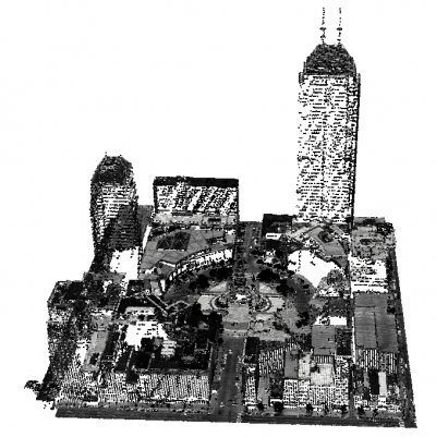
Oblique view of point cloud depicting downtown Indianapolis. Points are colored by intensity.
