OpenLandform Catalog
The OpenLandform Catalog from OpenTopography serves as a resource to explore geologic landforms in high-resolution topography for teachers, students, or any interested user. This resource brings real world cutting edge digital topographic data to an accessible level that can be interrogated and explored using free tools, such as Google Earth and QGIS. The catalog is intended to compliment advanced high school and introductory college level Earth science courses where the study and analysis of landscapes and landforms is essential to students' understanding of fundamental Earth system processes.
Below is a list of geologic landforms sourced from data hosted by OpenTopography separated into categories based on formative processes. Each category contains landforms displayed in hillshade (top image) and digital elevation model (DEM) (bottom image), a brief description of the landform, a link to the dataset page, and pre-generated data products. Each landform has links to numerous data products: images of the hillshade/DEM of the landform, Google Earth KMZ file, DEM including derived products (hillshades, contours, and slope maps), a STL file for 3D printing, and the point cloud data (LAZ).
The STL files are ready to be imported into your 3D printer software and printed. If you do not have access to a 3D printer, there are a variety of websites that provide 3D printing services such as Craftcloud, 3D Experience Marketplace, and Treatstock. You can find resources and tutorials on 3D printing digital elevation models here.
Landforms created by...
| Wind Action | Impacts and Landslides | Water | Faulting, Folding, and Earthquakes | Volcanic Activity |
Know of a landform that looks spectacular in lidar imagery?
Send the location to OpenTopography!
Wind Action
  |
Aeolian Sand DunesWhite Sands National Monument, New Mexico A dune is a hill or ridge of sand deposited by wind or water. Aeolian sand dunes are deposited on land and shaped and transported by wind. White Sands National Monument is an aeolian dune field containing several different types of dunes. This particular dune field contains Barchan dune types, which are shaped by the predominant southwestern winds, as well as Parabolic Dunes, which are partially anchored by vegetation. Movement of dune crests at White Sands can be up to 38 feet per year. For more information about the geology of White Sands National Monument, please read Geology of the White Sands Dunefield by the National Park Service. |
Impacts and Landslides
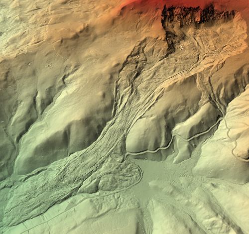
LandslideAlaska Range along Denali-Totschunda Fault System, Alaska A landslide is a downslope movement of a mass of rock and accumulated materials. Landslides are a type of mass wasting and can be triggered by earthquakes, heavy rains, or human activities such as construction or mining. Pictured to the right is an oblique view of a landslide adjacent to the Denali Fault. The last major rupture on this fault system was a magnitude 7.9 earthquake on November 3, 2002, which may have caused this landslide. In the bottom image, the lineament of a fault is visible going from higher to lower elevation. The top image is a slope-shade model, where steeper slopes are darker and gentler slopes are lighter. Notice that there are dark, round spots in the landslide patch, which are large boulders displaced by the event. |
  |
  |
EarthflowSlumgullion Earthflow, Colorado Earthflows are a specific type of landslide and mass wasting. In an earthflow, fine-grained materials that have been saturated with water flow down slope, resulting in a lobe-shaped landform. The Slumgullion Earthflow is located in the San Juan Mountains of Colorado and first formed 700 years ago. Its movement dammed part of a river and formed a natural lake. The current active part of the earthflow (shown in images to the left) has been active for the last 300 years. The slow-moving earthflow currently travels up to 1 cm/day and 7 m/year. |
Terrestrial Impact CraterBarringer Meteor Crater, Winslow, Arizona Meteor Crater is a terrestrial impact crater in northeastern Arizona. It is ~1,200 meters in diameter and ~170 meters deep. The rim of the crater rises ~45 m from the adjacent desert floor. The crater was created about 50,000 years ago when a ~50 meter-wide asteroid across struck the plain. Meteor Crater has been used to train astronauts, field test lunar explorers, and studied as an analog for other impacted terrains like the Moon. |
  |
Water
  |
Alluvial FanDeath Valley National Park, California An alluvial fan is a low, fan shaped deposit formed of water-transported sediment. Alluvial fans typically form at the exit of a narrow canyon, where the stream channel suddenly opens out to a flatter, broader area. This transition to a broad, unconfined area reduces the carrying capacity of the stream, resulting in the deposition of sediments. Repeated hydraulic events migrates the deposition area along the fan building up material in the fan shape. Typically, only part of the fan will be active at any given time. The images shown are from Death Valley National Park, an arid region where flash flooding in the mountains can transport lots of sediment in a short amount of time. The top image shown here is a point cloud colored by intensity. For more information and pictures visit USGS's Death Valley National Park page. |
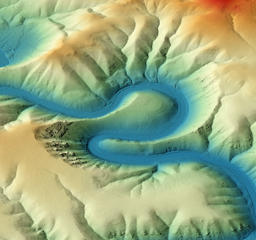
Entrenched MeandersYakima River, Washington The path of a river naturally meanders, or curves in a sinuous pattern. When a river erodes and cuts down into bedrock, its meanders can become entrenched. The Yakima River in Washington flows through Miocene-aged Columbia River basalts called the Yakima fold-thrust belt. Its meanders have deeply incised and cut down into the rock units, creating a canyon with gorge-like sections. |
|
Ice
MorainesTeton Front Range, Wyoming A moraine is a large mass of unconsolidated material that has been created by the movement of a glacier. Rocks that make up moraines can be as fine as silt to as large as a boulder, demonstrating the transport power of a glacier. There are several types of moraines, depending on where they formed with respect to the glacier. Lateral moraines (pictured) off the Teton Range formed perpendicular to the range front as the glaciers amassed at higher elevations. At the end of the two parallel lateral moraines is a terminal moraine, which is where the glacier ended. You can see that there are several terminal moraines that mark the receding glacier's toe. For more about the role of glaciers in the Teton Range, visit The Geologic Story of Grand Teton National Park from the National Parks Service. |
  |
Faulting, Folding and Earthquakes
Tectonic Landforms are indicative of a history of active faulting, and the exploration of these surficial landforms and data that is derived from high-resolution topographic data help reveal the complexities of fault zones. High-resolution lidar and derived products paired with a basic understanding of plate tectonics enables students to perceive the temporal and spatial extent of tectonic landforms, the earthquake cycle, and become aware of seismic hazard. As faulting, folding, and earthquakes create a myriad of examples, the exploration of high-resolution topography addresses a range of topics emphasizing tectonic geomorphology, the earthquake cycle, plate tectonics/structural geology, topographic measurement, visualization, fluvial and hillslope geomorphology, and the Earth as a system in which humans play a significant role.
EarthScope, funded by the National Science Foundation, was an organization whose aim was to study the structure and evolution of North America and has been integral in the collection of many datasets from which these tectonic landform examples are drawn. EarthScope aided in the development of predictive models for earthquakes by unraveling the dynamic processes along faults, from stress build-up to catastrophic rock failure. Lidar data collected by Earthscope and hosted by OpenTopography enables scientists, teachers, and the interested public to observe the processes and properties of faults that drive earthquakes.
Landforms Created by Strike-Slip Faults
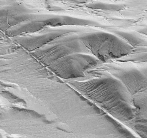 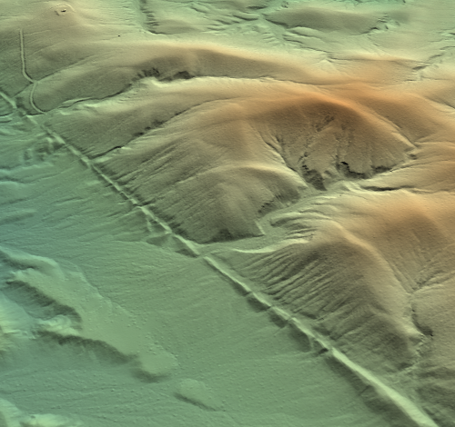 |
Strike-Slip Fault TraceGarlock Fault Zone, Ridgecrest, CA When earthquakes occur on faults with pure strike-slip motion, it creates a linear zone of mangled, easily eroded rock that over time forms a distinct fault trace. Fault lines on geologic maps are typically plotted following the visible fault trace on the surface. The example shown here is a segment of the Garlock Fault that cuts through part of a small range, leaving a distinct fault trace on the surface. |
Offset DrainageWallace Creek, San Andreas Fault, Carrizo Plain National Monument, CA Wallace Creek is a prime example of a drainage area that has been physically altered by active faulting, resulting in an offset channel. An offset channel occurs when a channel that would normally be somewhat straight, crosses an active strike-slip fault and is physically "beheaded" by the movement of the downstream plate in one or numerous earthquakes. For more information about the geologic history of Wallace Creek, please read The San Andreas fault at Wallace Creek, San Luis Obispo County, California field guide by Kerry Sieh and Robert Wallace. Exercise: Wallace Creek Student Field Trip Guide: The goal of this exercise is to give a better understanding to students about the earthquake cycle, strike-slip faulting, plate boundaries, and plate motion using Wallace Creek on the San Andreas Fault in California as an example. |
 
|
  |
Sag PondSan Andreas Fault, California Central Coast Range Sag ponds, also called "pull-apart basins," are local depressions—sometimes with water—that form between extensional bends or stepovers in a fault zone. In the images here, two fault traces can be distinguished. The upper image is a slope map, where the gentler slopes are lighter colors. Since this is a right step on the San Andreas fault (right lateral), a localized area of extension is formed, creating the sag pond. The sag pond is the depression seen in the center of the images. |
Pressure RidgeDragon's Back Pressure Ridge, Carrizo Plain National Monument Pressure ridges are topographic ridges ranging in size from a small meter scale mound to a lateral ridge several kilometers long. They are the surface expression of one or more earthquakes on specific fault geometries. Some of these known geometries include compressional bends or stepovers on strike-slip faults. Pressure ridges can provide a way to determine a fault's subsurface geometry and uplift history. The Dragon's Back pressure ridge (pictured) along the San Andreas Fault was formed as to the result of an obstruction on the fault plane's surface at depth, which acts as a bump that manifests as local uplift. Exercise: Advanced analysis of basins along the Dragon's Back using GIS software. This exercise is intended for those familiar with ArcGIS and involves modeling basins along the Dragon's Back in order to quantify and compare basins in active uplift versus non-active uplift areas. |
  |
Landforms Created by Normal Faults
Normal Fault ScarpGrand Teton National Park, Wyoming Normal faulting accommodates extension in the Earth's crust and is expressed on the surface as inclined fractures where blocks have mostly shifted vertically. A normal fault scarp forms when the hanging wall block has moved downward relative to the footwall block during an earthquake. Pictured is a normal fault scarp at the base of the Teton Mountain range in Wyoming. The fault runs approximately perpendicular to moraines—remnant glacial features—creating a well-defined fault scarp as the break in slope moving up and down the rangefront. |
 
|
Landforms Created by Reverse Faults
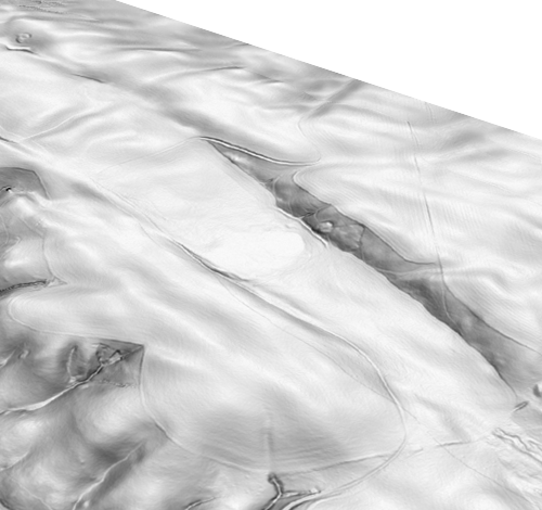
AnticlineUmtanum Ridge Anticline, Washington An anticline is an upward, individual bend or warp in a rock sequence. Pictured here is the Umtanum Ridge anticline, Washington, which is part of a larger province of compressed Miocene Columbia River basalts called the Yakima fold-thrust belt. In the slope map image (top), the rock layers are discernible as the darker areas making an upward arch of rock layers. |
 
|
Volcanic Activity
  |
Cinder ConeSunset Crater, Arizona A cinder cone is a conical shaped mass built by the accumulation of pyroclastic material ejected during volcanic eruptions. Cinder cones are the most common type of volcano in the world and are typically monogenetic, meaning they are produced during a single eruptive episode. The cinder, or scorias, of which they are made of are fragments of solidified lava that have vesicles, which are bubble-like cavities. Over time, the ejected material accumulates to form the cone shape. Sunset Crater is a cinder cone located north of Flagstaff, Arizona and is known for its nearly symmetrical shape. Its eruption in ~1085 CE was the most explosive monogenetic eruption ever documented, which significantly impacted pre-historic communities in the area. |
StratovolcanoMount Hood, Oregon A stratovolcano, also known as a composite volcano, is a tall, steep, conical-shaped volcano formed from multiple sequences of lava and tephra. Stratovolcanoes form at subduction zones due to flux melting, where water lowers the melting temperate of the mantle rocks. The melted magma then rises to the base of the crust into a magma chamber where it can be erupted by the stratovolcano. Mount Hood in Oregon is formed by a subduction zone where the Juan de Fuca Plate is being subducted under the North American Plate. Mount Hood is markedly taller and steeper than cinder cones like Sunset Crater as it is built up by many sequences of high-viscosity hardened lava flows. |
 
|
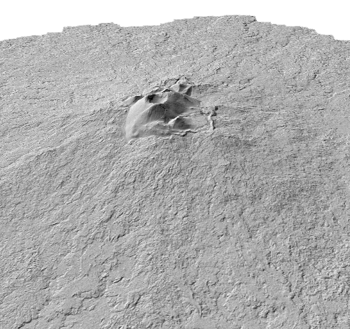 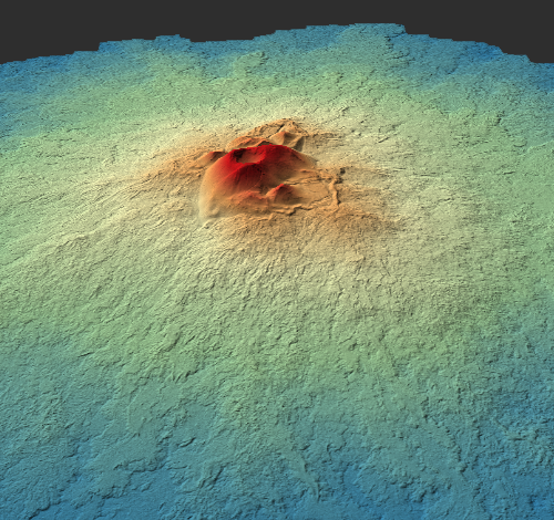 |
Shield VolcanoRangitoto Island, New Zealand Shield volcanoes are volcanoes with exceptionally shallow slopes and low profiles formed by the eruption of low viscosity lava flows. Rangitoto Island is a volcanic island that is part of the Auckland Volcanic Field in New Zealand, and it is the largest and youngest volcano in this volcanic field. Rangitoto Island is an ~6 km wide symmetrical shield volcano, with multiple small scoria cones at its summit. It most recently erupted during 1400‒1450 CE. In the lidar-derived imagery, you can see the morphology of the individual lava flows composing the shield, as well as the distinctive scoria cones that sit at the peak. |


