November 2025 Data Releases
Dec 3, 2025
OpenTopography provides easy, centralized access to a diverse collection of topographic data. We strive to simplify data discovery by providing a single, accessible platform that integrates data from a variety of sources including the USGS 3D Elevation Program (3DEP), NOAA Coastal Lidar, Natural Resources Canada, Polar Geospatial Center, and many more. Below are highlights of datasets that became available or were updated on the OpenTopography platform in November 2025.
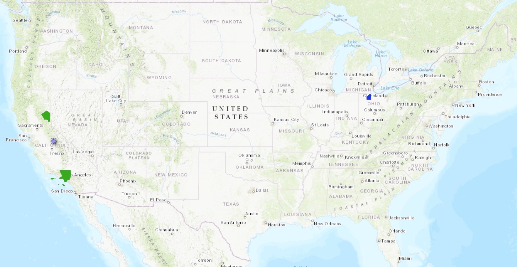
Location of new USGS 3DEP datasets in California (green polygons), new NOAA data in northern Ohio (blue polygon), and a new Community Dataspace dataset in Yosemite National Park (purple marker).
USGS 3D Elevation Program (3DEP) Datasets
The USGS is currently making 3DEP lidar point cloud data available via an Amazon Web Services (AWS) S3 Requester Pays Bucket, and as an AWS Public Dataset. To learn more about 3DEP and AWS see this USGS press release: USGS 3DEP Lidar Point Cloud Now Available as Amazon Public Dataset. Consistent with OpenTopography's mission of making high resolution topography data easier to discover and use, we provide a layer of value-added services that enable our users to subset, grid, download, and/or visualize any portion of the USGS 3DEP collection.
USGS 3DEP data is freely available to our core US academic user community (e.g. users who register with a .edu email domain). However, non-academics can access 3DEP data, as well as all other restricted datasets, by signing up for OpenTopography Plus (OT+). OT+ is a subscription service that enables one-stop, easy-to-use access to the highest quality lidar topography for the US. For more details about OT+, or to sign up, see the OT+ signup page.
New USGS 3DEP Datasets:
NOAA Coastal Lidar Datasets
The NOAA Coastal Lidar Data is a collection of lidar projects from many different sources and agencies, geographically focused on the coastal areas of the United States of America. The data are stored in the Entwine Point Tile format, and hosted on Amazon as part of the AWS Public Dataset Program. Consistent with OpenTopography's mission of making high resolution topography data easier to discover and use, we provide a layer of value-added services that enable our users to subset, grid, download, and/or visualize any portion of the NOAA Coastal Lidar collection.
NOAA Digital Coast data is freely available to our core US academic user community (e.g. users who register with a .edu email domain). However, non-academics can access NOAA data, as well as all other restricted datasets, by signing up for OpenTopography Plus (OT+). OT+ is a subscription service that enables one-stop, easy-to-use access to the highest quality lidar topography for the US. For more details about OT+, or to sign up, see the OT+ signup page.
New NOAA Coastal Lidar data:
OpenTopography Community Dataspace Datasets
The OpenTopography Community Dataspace allows users who are producing small to moderate sized topographic datasets (with technologies such as lidar and photogrammetry) to archive their data with OpenTopography via a simple drag and drop user interface. This feature is designed to support data publication and citation, academic data reuse, and educational applications. Each submission is reviewed by OpenTopography staff and approved on a case-by-case basis. Datasets in the OT Dataspace receive a Digital Object Identifier (DOI) and are displayed on the OpenTopography Find Data Map so they are discoverable and downloadable alongside data hosted by OpenTopography. The Dataspace is meant to complement standard OpenTopography data hosting for larger datasets produced by our data provider partners.
New Community Dataspace data:
Sample Graphics From Data Released in November 2025
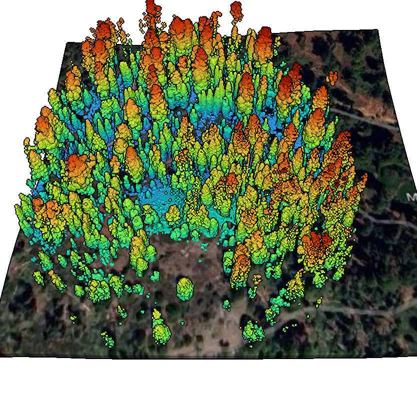
Colorized point cloud of mobile lidar scans in the Mariposa Grove of Giant Sequoias in California. Data Source: CDS: Mobile lidar scans in the Mariposa Grove of Giant Sequoias, California.
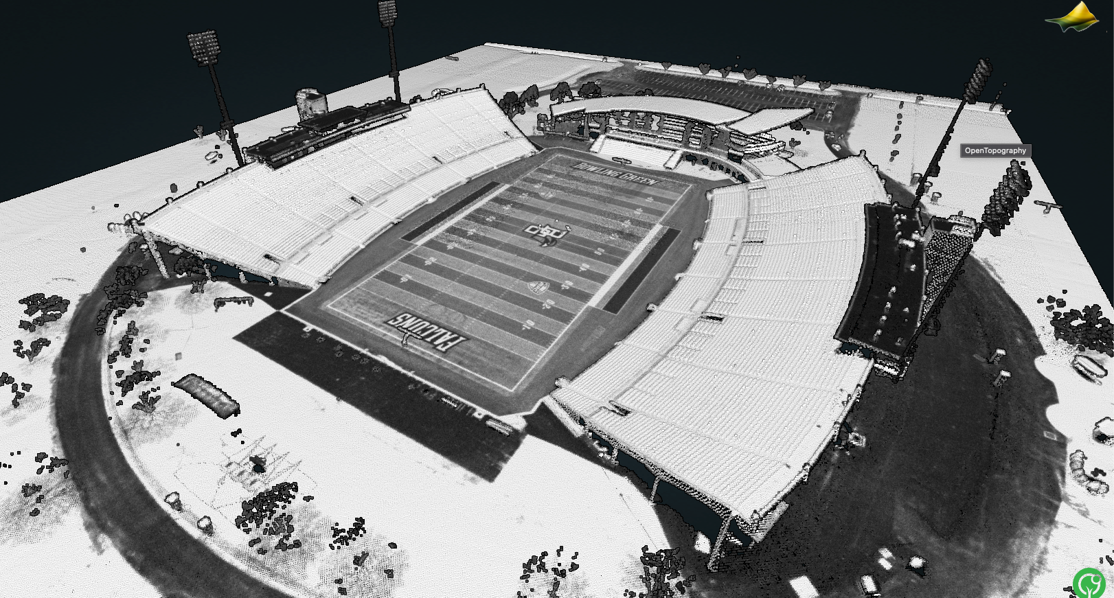
Lidar point cloud colored by intensity of the stadium at Bowling Green State University. Note the yard markings and end zone lettering can be seen due to the variation in the lidar return intensity between dark, light, and colored grass. Data Source: NOAA: 2022 OGRIP Lidar: Wood County, OH.
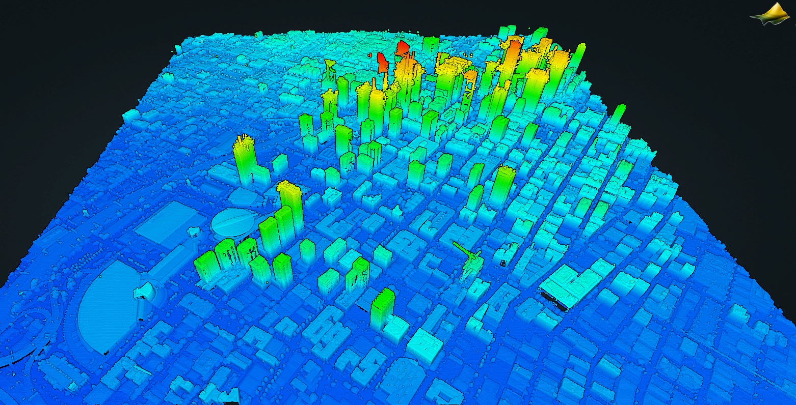
Lidar point cloud colored by elevation of downtown Los Angeles, California. Data Source: USGS 3DEP: CA LosAngeles 1 B23.