Exploring Topographic Change with 3D Prints
By Emily Zawacki
3D prints of landscapes provide a three-dimensional tactile way to explore the Earth’s surface and learn about the geologic processes that shape it. We can use topography data and create 3D prints of landscapes from digital elevation models. With 3D printing technologies, there is the potential for exploring areas of topographic change in a three-dimensional tactile way by creating 3D prints from pre- and post-event topography.
To demonstrate the potential of exploring topographic change with 3D prints, we created 3D prints of pre- and post-event topography from the Oso landslide that occurred near Oso, Washington in 2014. The prints were made using stereolithography (SLA) 3D printing, which uses a laser to cure liquid resin into a hardened plastic, producing fine features and high detail.

3D prints of pre-Oso landslide (left) and post-Oso landslide (right) made using stereolithography (SLA) resin 3D printing.
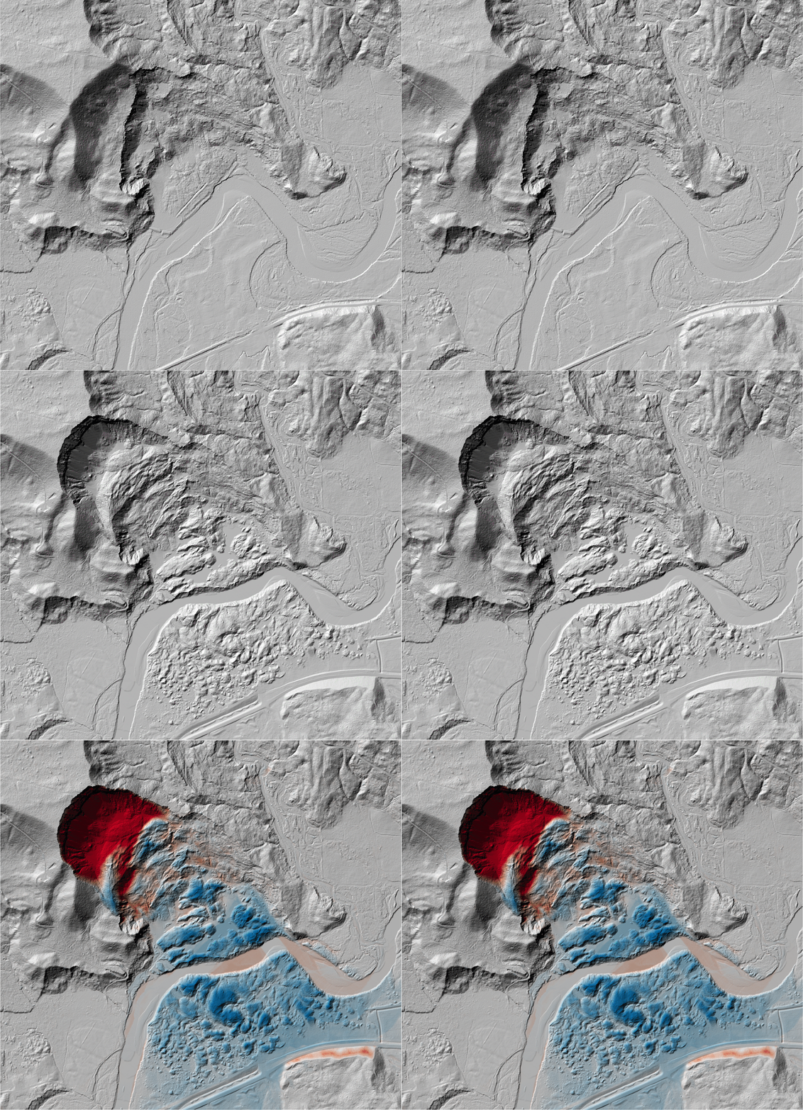
Vertical differencing of topography before and after the Oso landslide shows the large amount of erosion (red) at the head scarp of the landslide, where the failure initiated, and the deposition (blue) of material extending far into the valley, crossing over the river.

Hillshade showing topography before and after the Oso landslide, highlighting the topographic change (red = erosion, blue = deposition).
The 3D prints of pre- and post-topography highlight the volumetric change at the head scarp where the landslide originated and the steep nature of the scarp.

3D prints of pre-Oso landslide (left) and post-Oso landslide (right) showing the head scarp of the landslide.
Compared to the pre-landslide 3D print, the 3D print of post-landslide topography shows the hummocky surface texture from the landslide deposits, and the slight course change of the river as it eroded through these deposits.

3D prints of pre-Oso landslide (left) and post-Oso landslide (right) showing the deposits and toe of the landslide.
Through a tactile, three-dimensional exploration of topographic change, 3D prints provide a novel way to investigate how landscapes change over time.
Learn how to create 3D prints from digital elevation models HERE. Pre-made STL files of multiple landform types are available to download on our OpenLandform Catalog.
Topography datasets used to make the 3D prints:
Pre-landslide: 2013 NOAA Puget Sound LiDAR Consortium topography
Post-landslide: United States Geological Survey 3D Elevation Program 1 meter Digital Elevation Model
