New Point Cloud Data Available in Eastern California
Jun 11, 2015
OpenTopography is pleased to announce the release of two new datasets in eastern California: the Poleta Folds and Surprise Valley. The Poleta Folds airborne lidar data were collected by Chris Larson of the University of Alaska Fairbanks. This dataset is particularly exciting because the area is a beautiful example of classic structural geology, where many universities teach undergraduate mapping courses. The Poleta Folds data were funded by Central Washington University, Caltech, University of Alaska, Fairbanks, Sacramento State University, University of California, Davis, Oregon State University, University of California, Santa Cruz, and Western Washington University.
The Surprise Valley data collected by NCALM and funded by NASA ROSES encompass a seismically active geothermal area. It will be used to produce a high-resolution topographic base in order to map Quaternary fault scarps, correlated with an airborne magnetic survey collected in 2012.
NCALM is a NSF-funded center that supports the use of airborne laser mapping technology (a.k.a. lidar) in the scientific community and is jointly operated by the Department of Civil & Environmental Engineering, Cullen College of Engineering, University of Houston and the Department of Earth and Planetary Science, University of California, Berkeley. The release of these data via OpenTopography is the product of a memorandum of understanding (MOU) between OpenTopography and NCALM to make OT the primary distribution pathway for NCALM data.
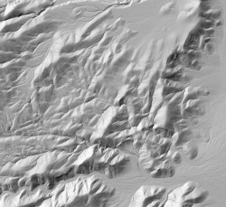
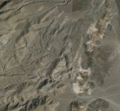
(Left) Hillshade image with slight transparency showing Poleta Folds, CA (Right) Google Earth image of Poleta Folds, CA