LAS Conversion Tools: LAStools and LASUtility
The ASPRS LAS format has become the standard for delivery of lidar point cloud data. However, because LAS is a binary format, a reader of some kind is necessary to ingest the data, visualize it, or perform additional analysis. Many of the major GIS software packages now support LAS (e.g. ArcGIS) and all of the commercial lidar specific software read and write LAS data. Some users however lack access to software that will read the LAS format and thus would like to view lidar point cloud data in ascii format. In these situations I typically recommend the excellent and free LAStools (or LAStools' Open Source Geospatial foundation relative libLAS), a package of utilities for reading and writing LAS files. The downside to LAStools is that the utilities are command line-based, which tends to scare away some users. If you are interested in LAStools, take a look at the short LAStools tutorial that we've used in past OpenTopography short courses.
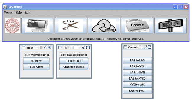
Today I learned about an alternative to LAStools, called LASUtility from an Indian company called GeoKno. Like LAStools, LASUtility offers the ability to view LAS headers, convert LAS data to ascii and vice versa, merge or subset LAS files, etc. However, LASUtility is a Java application that includes a graphical user interface (gui) to the commands unlike LAStools. The fact that it is a Java app also means that in theory LASUtility will run on platforms other than windows (the readme says Windows, Linnux, Solaris), but the download only includes a Windows executable. LASUtility is a free download, and a free 5 day license is available (read the "Readme.txt" file in the downloaded directory for info on obtaining a license). It is unclear to me if longer term licenses are free or require payment.
A quick test drive of LASUtility using a sample LAS file (~220 MB .las) indicated that it generally works as promised but is quite a bit slower than the command line LAStools. There also seems to to be less control over how file conversions are done - for example, the "LAS to XYZ" and "LAS to text" commands don't allow you to define the delimiter in the ascii file (files are written as tab delimited). On the plus side, LASUtility provides a simple (but slow) 3D viewer for the LAS file and claims to offer graphical sub-setting of files (allowing users to draw a bounding box), but I couldn't get the interface to launch.

If you are working with lidar point cloud data in LAS format, LAStools is a set of utilities that should definitely be part of your tool kit. If you are command line averse, LASUtility may also be worth a look.
