Updates Enhance Data Discovery, Increase Processing Speed, Add LAZ Support and More
It has been a busy fall at OpenTopography, with seemingly non-stop meetings, workshops and conferences to keep us busy. But fortunately the team has also been cranking away at adding significant improvements to the OT system. Over the past several months we've had two major software and system updates that added many features to OT, some of which are visible to users, while others are important updates to our underlying data management and processing systems. If you are a regular OT user you've likely noticed changes to the OT user interface as well as significant reductions in data access and processing times - these are exciting updates for us. The following is a summary of what we've updated, improved, and tweaked this fall:
OpenTopography v 3.4:
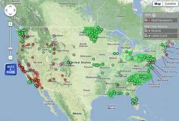
- New Find Data page which displays not only OpenTopography hosted-data, but also provides linkages to data hosted at the NCALM Data Distribution Center and USGS Center for Lidar Coordination and Knowledge (CLICK). The goal of this collaboration is to make it easier for lidar users to discover and link to online sources of data regardless of host. This is phase one of OpenTopography's work to facilitate data discovery, and we anticipate adding new partners to the Find Data page in 2012.
- Option to make all map-based pages in OT full width by hiding the left-hand menu. Click the "Enlarge Map" button to try it out.
- Support for LASzip (LAZ) as a point cloud download format. LASzip is an open source lossless compression for lidar point cloud data in the LAS format that provides significant file size reductions, helpful when downloading or storing large datasets.
- Improvements to the OT data statistics dashboard provided to our data provider partners
- Updates to underlying point cloud data access system yields ~30% faster queries
- Formalized data validation process and reporting to check incoming lidar point cloud for errors. Process also includes inserting coordinate system definition into datasets when not set by vendors.
- Tweak to TIN-based DEM generation tool to increase performance by ~17%
- Bug fixes and minor updates to user interface

OpenTopography v 3.5:
- Merged point cloud and pre-computed raster (DEM) data product access into a single dataset landing page to maintain consistent access to branding, metadata, etc.
- Migration of older datasets into modern OT point cloud data management system, yielding a massive (order of magnitude in some cases) speed up in data extraction times. Migration impacts all EarthScope lidar datasets, B4, NSAF and Rainier, and the ECSZ dataset.
- Updated server hardware, yielding approximately 30% improvement in point cloud extraction time and better scalability.
- Bug fixes and minor updates to user interface
