Thirteen Datasets from Eight States Available
OpenTopography is pleased to announce the release of thirteen datasets collected by the National Center for Airborne Laser Mapping (NCALM) over areas of Arizona, California, Colorado, Massachusetts, Nevada, New Mexico, Utah and Wyoming. NCALM is an NSF-funded center that supports the use of airborne laser mapping technology (a.k.a. lidar) in the scientific community and is jointly operated by the Department of Civil & Environmental Engineering, Cullen College of Engineering, University of Houston and the Department of Earth and Planetary Science, University of California-Berkeley. Nine datasets in this release were collected under NCALM's graduate student seed proposal program that awards ten projects per year to graduate student PIs who need lidar data for their research. Each collection is typically limited to no more than 40 square kilometers. The release of these data via OpenTopography is the product of a memoranda of understanding (MOU) between OpenTopography and NCALM to make OT the primary distribution pathway for NCALM data. With this release, OpenTopography now hosts 93% of the total NCALM catalog as we continue to work through a backlog of data going back to 2004.
- Niwot Ridge Long-Term Ecological Research Site, Colorado
- Perry Mesa, AZ: Ancient Agricultural Features and Landscape Transformation
- Truckee, CA: Sagehen Creek Snowpack Measurement
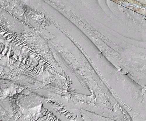
- Greybull, WY: Sheep Mountain Anticline
- San Gabriel Mountains, CA: Tectonics and Topography
- White Canyon and Hite, Lake Powell, Utah
- Henry Mountains, UT: Hillslope-Channel Coupling in a Bedrock Landscape
- Merced, CA: Origin and Evolution of the Mima Mounds
- Pahrump Valley: California/Nevada State Line
- Plum Island, MA
- Yellowstone National Park, WY: Quantifying Gravel-Bed Rivers
- White Sands National Monument, NM: LiDAR Survey of Dune Fields (Jan 2009)
- White Sands National Monument, NM: LiDAR Survey of Dune Fields (Sept 2009)

Lidar hillshade image of Sheep's Mountain Anticline in Google Earth . View from the north.
