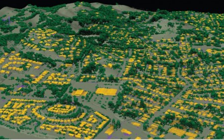
Sonoma County California Topography and Vegetation Data now Available
OpenTopography is pleased to announce the release of lidar point cloud and raster data covering Sonoma County, CA. These data are a result of a five year effort to map Sonoma County's topography and physical and biotic features, and diverse plant communities and habitats (at a 1:5,000 or higher mapping). Several organizations including the University of Maryland, NASA, and the Sonoma Veg Map program funded the collection and hosting of data on OpenTopography.
From Sonoma Veg Map, "These foundational data sets are key to facilitating good planning and management for watershed protection, flood control, fire and fuels management and wildlife habitat conservation. These data are also critical to assessing climate mitigation and adaptation strategies and benefits provided by the landscape, such as the amount of carbon sequestration in forests or the degree to which riparian areas, floodplains, and coastal habitats may buffer extreme weather events."
- Point Cloud: UMD-NASA Carbon Mapping /Sonoma County Vegetation Mapping and LiDAR Program
- Raster: UMD-NASA Carbon Mapping /Sonoma County Vegetation Mapping and LiDAR Program
If you have a lidar dataset you are interested in distributing through OpenTopography, please review our data submission process and contact us.

Classified lidar image of Peteluma, CA showing buildings (yellow), vegetation (green), structures (purple), and topography (grey).
