OpenTopography Team to Develop Cyberinfrastructure for NASA’s ICESat-2 Data
The San Diego Supercomputer Center (SDSC) and Scripps Institution of Oceanography at the University of California San Diego, in collaboration with Boulder, CO-based UNAVCO and the National Snow and Ice Data Center (NSIDC) have been awarded a NASA ACCESS grant to develop a cyberinfrastructure platform for discovery, access, and visualization of data from NASA’s ICESat and upcoming ICESat-2 laser altimeter missions.
ICESat and ICESat-2 (scheduled for launch in 2018) measure changes in the volume of Earth’s ice sheets, sea-ice thickness, sea-level height, the structure of forest and brushland canopies, and the distribution of clouds and aerosols.
The new project, dubbed “OpenAltimetry” (www.openaltimetry.org), will build upon technology that SDSC developed for its NSF-funded OpenTopography facility, which provides web-based access to high-resolution topographic data and processing tools for a broad spectrum of research communities.

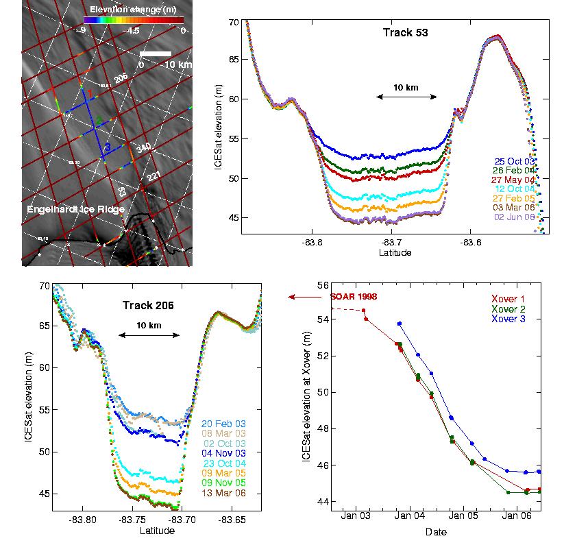
(Top left) ICESat 91-day tracks across newly discovered subglacial Lake Engelhardt in West Antarctica. Tracks are color-coded by elevation changes between October 2003 and November 2005. White asterisks locate tide-induced ice-flexure limits for the grounding line derived from ICESat repeat-track analysis. (Top right/bottom left) Repeat ICESat profiles along two tracks across the lake (see top left panel for locations). Track 206 was an almost exact repeat of an 8-day track. (Bottom right) ICESat elevations against time at three orbit crossovers in the center of the lake including the 8-day data at crossover 1 in February/March 2003. Image courtesy of Fricker, Helen Amanda; Ted Scambos; Robert Bindschadler; Laurie Padman: "An Active Subglacial Water System in West Antarctica Mapped from Space." Science 315, no. 5818 (2007): 1544-1548.

