New Research Publication: Utilizing Differential Lidar for Understanding Surface Deformation
A new paper, authored by OpenTopography staff, has been published recently that utilizes lidar and high resolution differential topography for understanding behavior of the shallow fault zone in large surface-rupturing earthquakes.
Summary:
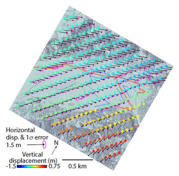
Three-dimensional near-fault coseismic deformation fields from high-resolution differential topography provide new information on the behavior of the shallow fault zone in large surface-rupturing earthquakes. Scott et al.’s research focuses on the 16 April 2016 M7.0 Kumamoto, Japan, earthquake, which ruptured ~40 km of the Futagawa-Hinagu Fault Zone on Kyushu Island with an oblique strike-slip mechanism and surface offset exceeding 2 m. They use a windowed implementation of the Iterative Closest Point algorithm to image the 3D on- and off-fault surface deformation. They show that 36+/-29% and 62+/-32% of the horizontal and vertical deformation, respectively, was accommodated off the principal fault and that the elastic strain limit was exceeded over a 250 m width along many portions of the rupture.
The pre- and post- Kumamoto lidar datasets used in this publication are available from OpenTopography thanks to Air Asia Survey Co., Ltd. who agreed to work with the authors and OpenTopography to publish the data:
- April 15, 2016 Pre-Kumamoto Earthquake Rupture Lidar Scan
April 23, 2016 Post-Kumamoto Earthquake Rupture Lidar Scan
Citation:
Scott, C., Arrowsmith, J R., Nissen, E., Lajoie, L., Maruyama, T., Chiba, T., (2018). The M7 2016 Kumamoto, Japan, Earthquake: 3D deformation along the fault and within the damage zone constrained from differential lidar topography, Journal of Geophysical Research. doi:10.1016/j.earscirev.2015.05.012
Figure of coseismic surface displacements along a conjugate shear zone with 1 sigma errors on the horizontal surface displacements shown by the pink ellipses. Orange lines show faults activated in the 2016 earthquake mapped from the post-earthquake lidar imagery.

