New Point Cloud Data Available from Puerto Rico, Oregon, California and Colorado
Five datasets covering areas of Puerto Rico, Oregon, California and Colorado are now available through the OpenTopography portal. Data were collected for various purposes including refining algorithms for vegetation classification, debris flow sediment storage and mechanics, and studying river terrace formation and abandonment.
Luquillo Critical Zone Observatory Data::
Under OpenTopography's memorandum of understanding with the six NSF Critical Zone Observatories, we will be hosting all lidar data products collected to support research at the CZO sites. The CZOs are environmental laboratories established to study the chemical, physical and biological processes that shape the Earth's surface, and thus lidar is one of several tools being utilized. The Luquillo CZO includes the Rio Mameyes, Rio Blanco watersheds and coastal zones in Puerto Rico.
National Center for Airborne Laser Mapping Datasets (NCALM):
NCALM is a NSF-funded center that supports the use of airborne laser mapping technology (a.k.a. lidar) in the scientific community and is jointly operated by the Department of Civil & Environmental Engineering, Cullen College of Engineering, University of Houston and the Department of Earth and Planetary Science, University of California, Berkeley. Two datasets were collected under NCALM's graduate student seed proposal program that awards ten projects per year to graduate student PIs who need lidar data for their research. Each collection is typically limited to no more than 40 square kilometers. The release of these data via OpenTopography is the product of a memorandum of understanding (MOU) between OpenTopography and NCALM to make OT the primary distribution pathway for NCALM data.
- Oregon Coast Range: Sediment Storage in Debris-Flows
- South Fork Eel River, CA: Understanding Terrace Formation and Abandonment
- West Bijou Creek, CO
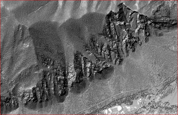
- San Isabel NF, CO: Debris Flow Mechanics and Landscape Evolution

Hillshade image showing debris slopes in San Isabel National Forest, CO
