May 2025 Data Releases
May 29, 2025
OpenTopography provides easy, centralized access to a diverse collection of topographic data. We strive to simplify data discovery by providing a single, accessible platform that integrates data from academic, private, and federal sources, including the USGS 3D Elevation Program (3DEP) and NOAA Coastal Lidar. Below are highlights of datasets that became available on the OpenTopography platform in May 2025.
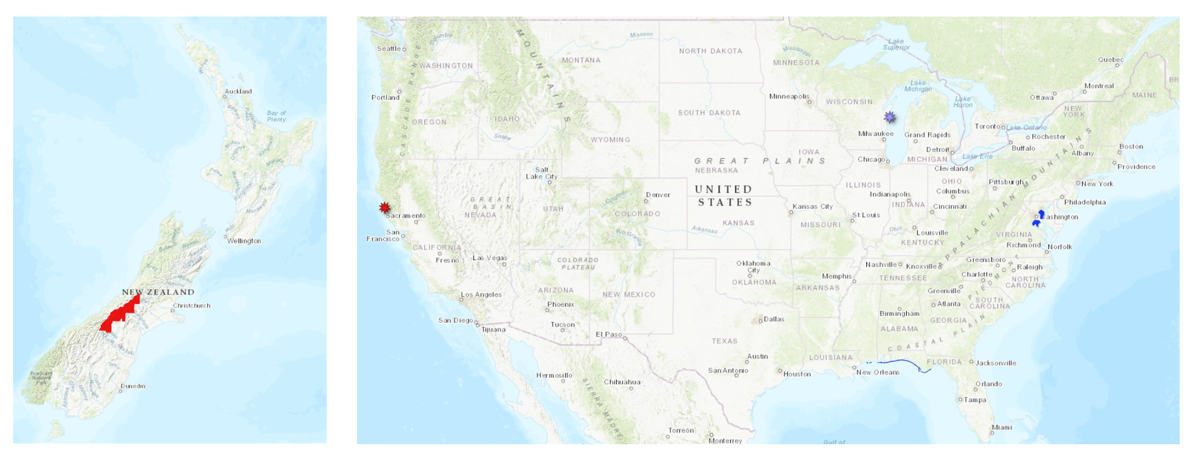
Left hand panel shows new Land Information New Zealand (LINZ) dataset coverage added in May 2025 in red. Right hand panel shows the location of a new Community Dataspace dataset in purple on the coast of Lake Michigan, new NOAA datasets in blue in the DC area and along the Florida coastline, and a new OpenTopography hosted dataset in Northern California in red.
Land Information New Zealand (LINZ) Datasets
OpenTopography has an on ongoing collaboration with Land Information New Zealand that makes OpenTopography the primary distribution platform for point cloud data collected as part of the LINZ national elevation program.
New Land Information New Zealand data:
OpenTopography Community Dataspace Datasets
The OpenTopography Community Dataspace allows users who are producing small to moderate sized topographic datasets (with technologies such as lidar and photogrammetry) to archive their data with OpenTopography via a simple drag and drop user interface. This feature is designed to support data publication and citation, academic data reuse, and educational applications. Each submission is reviewed by OpenTopography staff and approved on a case-by-case basis. Datasets in the OT Dataspace receive a Digital Object Identifier (DOI) and are displayed on the OpenTopography Find Data Map so they are discoverable and downloadable alongside data hosted by OpenTopography. The Dataspace is meant to complement standard OpenTopography data hosting for larger datasets produced by our data provider partners.
New Community Dataspace data:
OpenTopography Hosted Datasets
The majority of datasets hosted directly by OpenTopography are free and open to all users. Highlighting the value of historical geospatial data, OpenTopography is pleased to announce the addition of an early lidar test dataset from 2003, collected over Caspar Creek, California. This ground-only dataset was provided by the National Center for Airborne Laser Mapping (NCALM) . The open distribution of such datasets are vital, as they offer an invaluable baseline for tracking changes and can significantly enrich future scientific studies in dynamic landscapes.
New OpenTopography hosted data:
NOAA Coastal Lidar Datasets
The NOAA Coastal Lidar Data is a collection of lidar projects from many different sources and agencies, geographically focused on the coastal areas of the United States of America. The data are stored in the Entwine Point Tile format, and hosted on Amazon as part of the AWS Public Dataset Program. Consistent with OpenTopography's mission of making high resolution topography data easier to discover and use, we provide a layer of value-added services that enable our users to subset, grid, download, and/or visualize any portion of the NOAA Coastal Lidar collection.
NOAA Digital Coast data is freely available to our core US academic user community (e.g. users who register with a .edu email domain). However, non-academics can access NOAA data, as well as all other restricted datasets, by signing up for OpenTopography Plus (OT+). OT+ is a subscription service that enables one-stop, easy-to-use access to the highest quality lidar topography for the US. For more details about OT+, or to sign up, see the OT+ signup page.
New NOAA Coastal Lidar data:
- 2020 Maryland Lidar: Anne Arundel County, MD
- 2023 Maryland Lidar: Charles County, MD
- 2022 USACE NCMP Topobathy Lidar: Gulf Coast (AL, FL, MS)
Sample Graphics From Data Released in May 2025
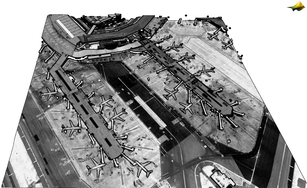
3D point cloud colored by intensity of a section of the BWI terminal outside of Baltimore, MD. Data Source: NOAA: 2020 Maryland Lidar: Anne Arundel County, MD
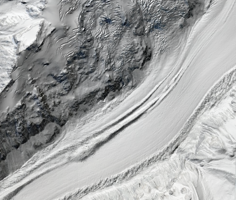
Hillshade of a section of the Tasman Glacier in New Zealand. Data Source: LINZ: Canterbury, New Zealand 2020-2025.
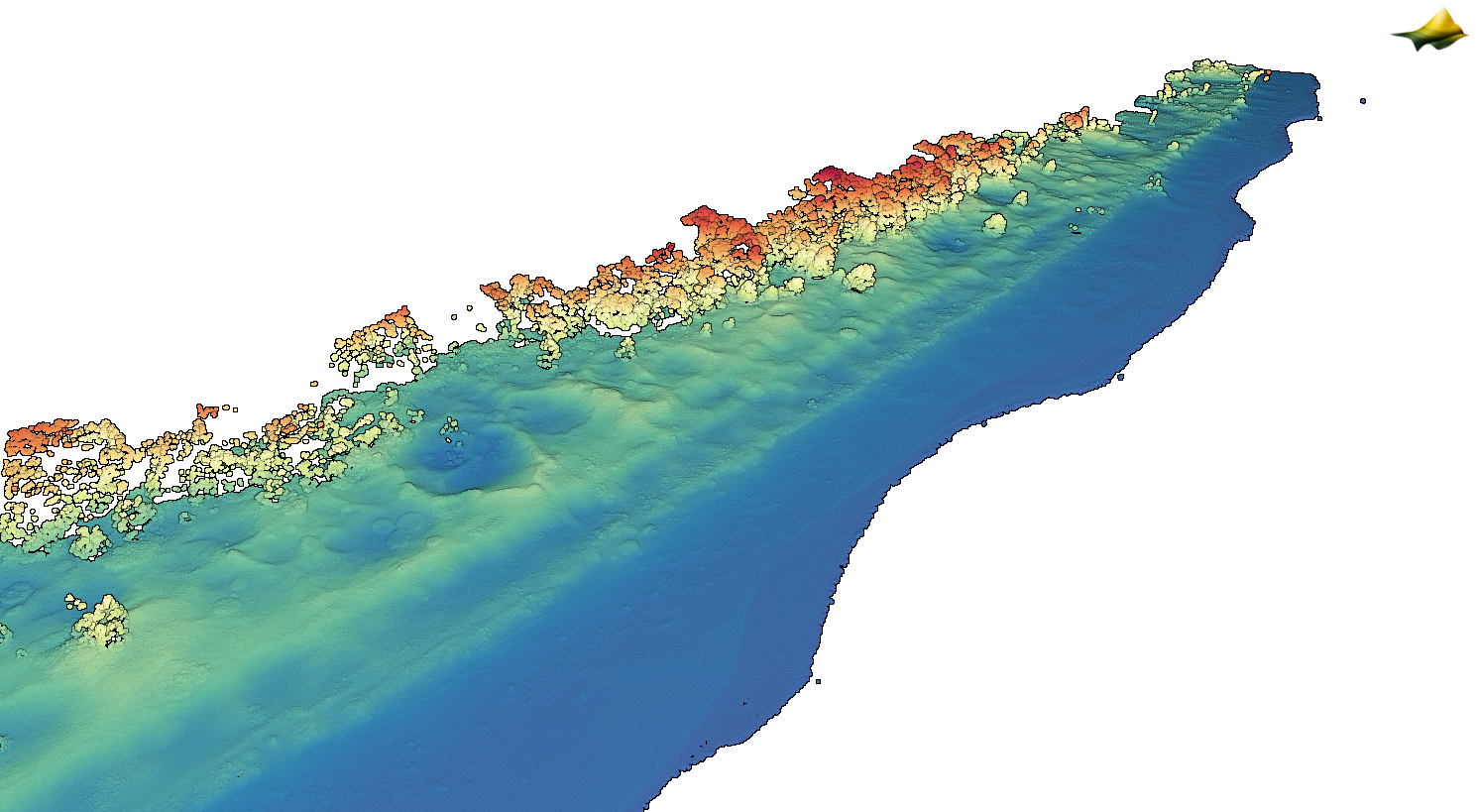
3D point cloud colored by RGB over a section of the Lake Michigan coastline. Data Source: Community Dataspace: Survey of Point Beach State Forest, Wisconsin, September 2023.