Eight Datasets Available for the Channel Islands, Wyoming, Idaho, Utah, New Mexico and Texas
We are pleased to announce the release eight new datasets covering various unique areas of the United States. Seven of the datasets were collected by the National Center for Airborne Laser Mapping (NCALM) for hydrological and biological studies in Wyoming, Idaho, Utah, New Mexico and Texas. The Channel Islands dataset was collected for the United States Geological Survey (USGS) and includes all of the islands of Channel Islands National Park: San Miguel, Santa Rosa, Anacapa, Santa Barbara, and Santa Cruz.
National Center for Airborne Laser Mapping (NCALM):
NCALM is an NSF-funded center that supports the use of airborne laser mapping technology (a.k.a. lidar) in the scientific community and is jointly operated by the Department of Civil & Environmental Engineering, Cullen College of Engineering, University of Houston and the Department of Earth and Planetary Science, University of California-Berkeley. These ten datasets were collected under NCALM's graduate student seed proposal program that awards ten projects per year to graduate student PIs who need lidar data for their research. Each collection is typically limited to no more than 40 square kilometers. The datasets released in this batch are seed proposal collections performed in 2011. The release of these data via OpenTopography is the product of a memoranda of understanding (MOU) between OpenTopography and NCALM to make OT the primary distribution pathway for NCALM data.
- Medicine Bow NF, WY: Forest Ecosystem Impacts by Mountain Pine Beetle
- Bitterroot NF, ID: Transient Hillslope Response to Knickpoint Migration
- Boise NF, ID: Avalanche Forecasting and Acoustic Detection
- Cache NF, UT: Predicting Bonneville Cutthroat Trout Spawning Hotspots
- Hite, UT: Quantifying the Evolution and Stability of Coarse Alluvial Channels
- Lincoln National Forest, NM: Floodplains in Fluvial Networks
- Corpus Cristi, TX: Influence of Dunes & Barrier Islands on Hurricane Surge
2010 Channel Islands Lidar Collection:
The United States Geological Survey partnered with the Nature Conservancy and the National Parks Service to collect lidar data of the five islands comprising Channel Islands National Park. The project area totals about 288 square miles (747 square kilometers). Helicopters were used to collect airborne lidar and establish GPS ground control on all five islands.

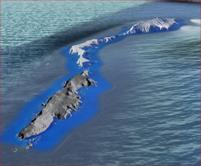
East Anacapa Island hillshade in foreground with Middle and West Anacapa islands in the background with imagery from Google Earth. Taken from 2010 Channel Islands Lidar Collection. Oblique view looking east.
