April 2026 Data Releases
May 1, 2026
OpenTopography added new high resolution datasets in April 2026, including lidar surveys supporting vegetation and ecology research in fire-prone Southern California regions and slot canyon studies in Arizona. New USGS 3DEP datasets in Nevada, Ohio, and Oregon, along with Community Dataspace datasets from China, Virginia, and Iceland are also now available.
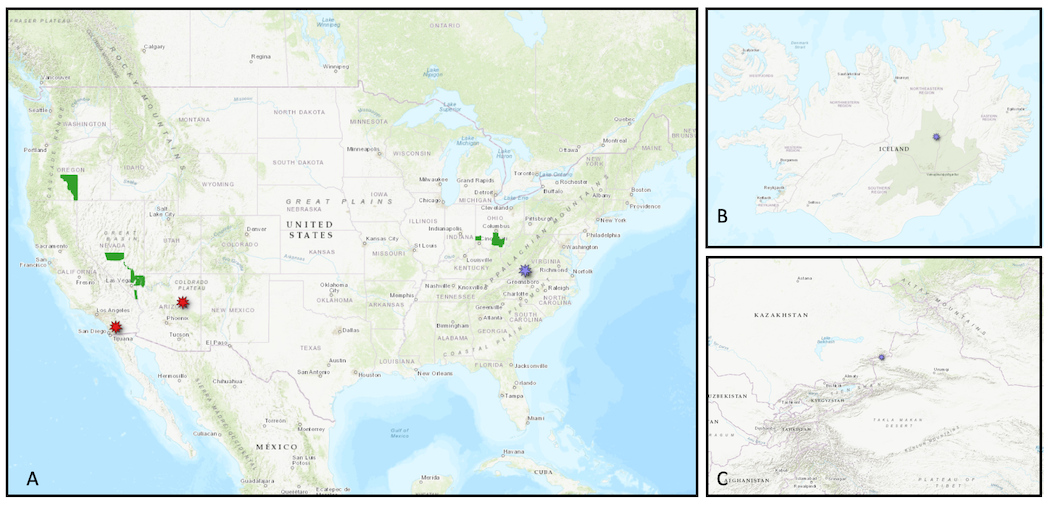
A. Locations of new USGS 3DEP datasets (green polygons), OT-hosted datasets in California and Arizona (red markers), and a Community Dataspace dataset in Virginia (purple marker). B. New Community Dataspace dataset in Iceland (purple marker). C. New Community Dataspace dataset in north western China (purple marker)
OpenTopography Hosted Datasets
A new dataset from San Diego State University was collected to provide high-density, contemporary ground-truth data on 3D vegetation structure in the fire-prone montane ecosystems of Southern California. This dataset served as a benchmark for developing and validating deep learning models designed to enhance sparse, historical airborne light detection and ranging (lidar) data by fusing it with multi-temporal optical National Agriculture Imaging Program (NAIP) and L-band synthetic aperture radar (UAVSAR) imagery for applications in ecological modeling and land management
In addition, a new lidar dataset was collected in Arizona as part of an NCALM Seed grant for Brandon Fong at Pennsylvania State University and Michael Robinson at the University of Nevada, Reno. This dataset was acquired to help characterize slot canyon formation and morphology over large spatial scales.
New OpenTopography hosted data:
- UAV Lidar Survey of Volcan Mountain Wilderness Preserve, CA 2024
- Lithologic Controls on Slot Canyon Formation, AZ 2025
USGS 3D Elevation Program (3DEP) Datasets
The USGS is currently making 3DEP lidar point cloud data available via an Amazon Web Services (AWS) S3 Requester Pays Bucket, and as an AWS Public Dataset. To learn more about 3DEP and AWS see this USGS press release: USGS 3DEP Lidar Point Cloud Now Available as Amazon Public Dataset. Consistent with OpenTopography's mission of making high resolution topography data easier to discover and use, we provide a layer of value-added services that enable our users to subset, grid, download, and/or visualize any portion of the USGS 3DEP collection.
USGS 3DEP data is freely available to our core US academic user community (e.g. users who register with a .edu email domain). However, non-academics can access 3DEP data, as well as all other restricted datasets, by signing up for OpenTopography Plus (OT+). OT+ is a subscription service that enables one-stop, easy-to-use access to the highest quality lidar topography for the US. For more details about OT+, or to sign up, see the OT+ signup page.
New USGS 3DEP Datasets:
OpenTopography Community Dataspace Datasets
The OpenTopography Community Dataspace allows users who are producing small to moderate sized topographic datasets (with technologies such as lidar and photogrammetry) to archive their data with OpenTopography via a simple drag and drop user interface. This feature is designed to support data publication and citation, academic data reuse, and educational applications. Each submission is reviewed by OpenTopography staff and approved on a case-by-case basis. Datasets in the OT Dataspace receive a Digital Object Identifier (DOI) and are displayed on the OpenTopography Find Data Map so they are discoverable and downloadable alongside data hosted by OpenTopography. The Dataspace is meant to complement standard OpenTopography data hosting for larger datasets produced by our data provider partners.
New Community Dataspace data:
- Survey of Displaced Geomorphic Surfaces of the Bole Fault, China 2024
- Virginia Tech StREAM Lab Spring 2017 Drone Lidar Survey
- Backpack LiDAR scans from a sand covered lava margin at Holuhraun (Iceland)
Sample Graphics From Data Released in April 2026
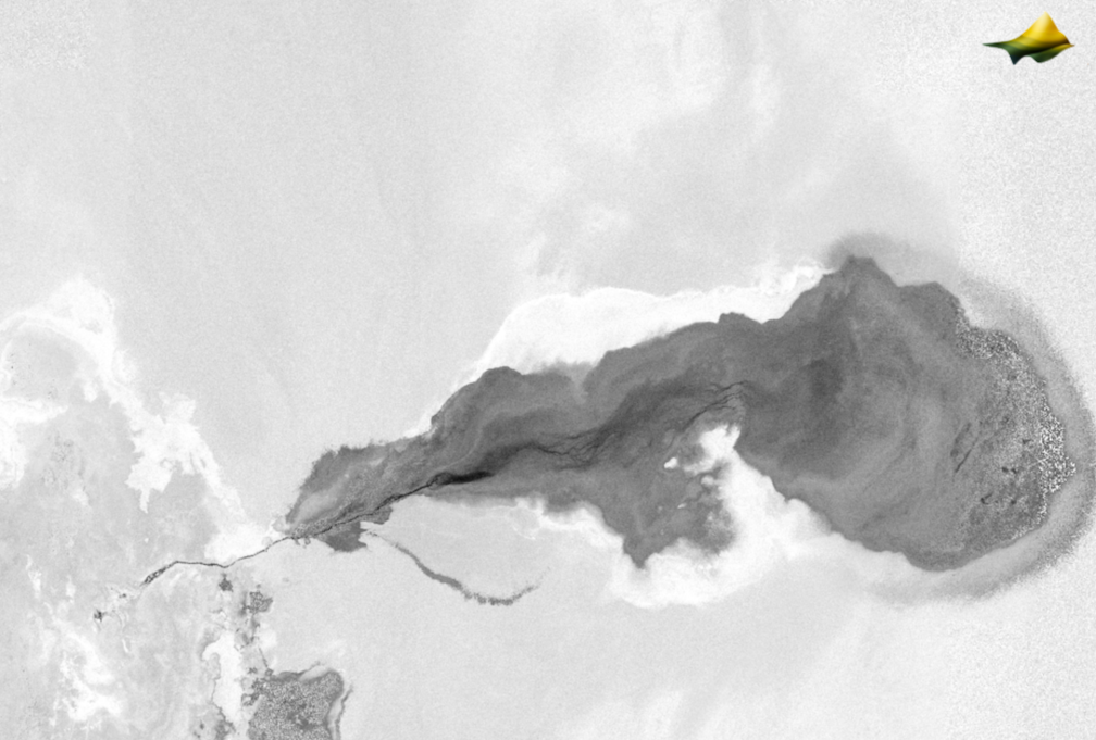
3D Point cloud colored by intensity of sediment transport into Summer Lake in Oregon. Data Source: USGS 3DEP: OR SouthEast 1 D22
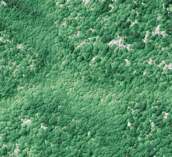
Canopy Height Model created from a section of the Great Seal State Park, Ohio. Darker greens indicate taller trees. Data Source: USGS 3DEP: OH StatewideP3 7 B21
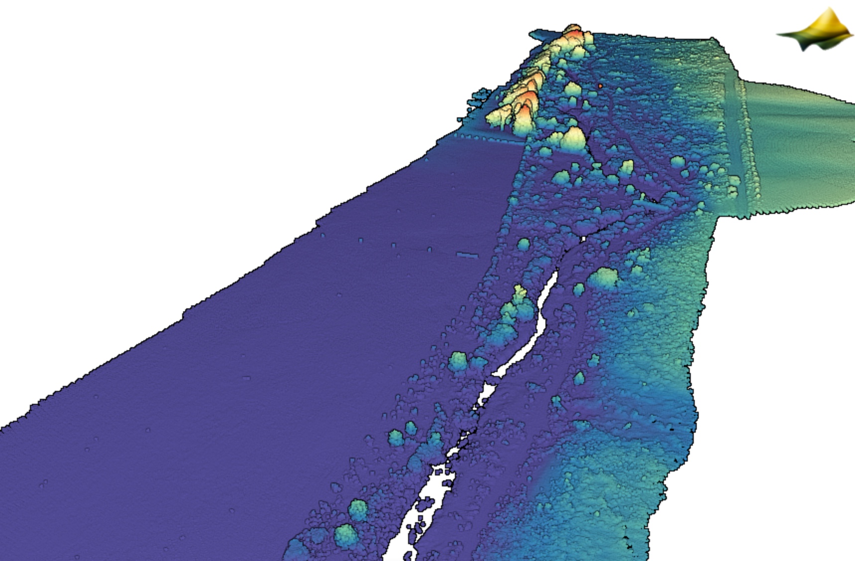
3D point cloud colored by elevation of the Virginia Tech StREAM Lab. Data Source: Community Dataspace: Virginia Tech StREAM Lab Spring 2017 Drone Lidar Survey.
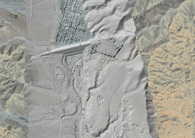
Hillshade of dam in north western China draped on Google imagery. Data Source: Community Dataspace: Survey of Displaced Geomorphic Surfaces of the Bole Fault, China 2024.