90m SRTM Elevation Data and NCALM Google Earth Files now Available
OpenTopography recently released our first near-global satellite dataset as well as 20 new Google Earth files. The Shuttle Radar Topography Mission (SRTM) is a near-global 90 meter resolution raster dataset. New Google Earth lidar imagery files are for lidar datasets collected by the National Center for Airborne Laser Mapping (NCALM) between 2003 and 2007..
Shuttle Radar Topography Mission (SRTM) data
The Shuttle Radar Topography Mission (SRTM) obtained 90 meter resolution data on a near-global scale to generate the most complete high-resolution digital topographic database of Earth. SRTM consisted of a specially modified radar system that flew onboard the Space Shuttle Endeavour during an 11-day mission in February of 2000. SRTM is an international project spearheaded by the National Geospatial-Intelligence Agency (NGA) and the National Aeronautics and Space Administration (NASA). These data can be accessed via the SRTM dataset landing page page or added to queries of other raster datasets.

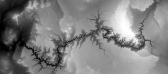
Raster image (90m) of the Grand Canyon, Southwest United States.
NCALM Google Earth Lidar Imagery Files
In addition to point cloud, custom DEMs, and pre-generated DEMs, OpenToporaphy has now added Google Earth files for 20 datasets collected between 2003 and 2007 by the National Center for Airborne Laser Mapping (NCALM). The Google Earth files include highest hit, bare earth and intensity (for certain datasets) layers. NCALM is a NSF-funded center that supports the use of airborne laser mapping technology (a.k.a. lidar) in the scientific community and is jointly operated by the Department of Civil & Environmental Engineering, Cullen College of Engineering, University of Houston and the Department of Earth and Planetary Science, University of California, Berkeley. The release of these data via OpenTopography is the product of a memorandum of understanding (MOU) between OpenTopography and NCALM to make OT the primary distribution pathway for NCALM data.
