2014 Post South Napa Earthquake data now available
OpenTopography is pleased to announce the release of high resolution point cloud data collected after the 2014 South Napa Earthquake. The August 24, 2014, South Napa earthquake (M6.0) produced significant damage resulting from shaking, fault rupture, fault afterslip, and ground deformation. Lidar data were collected to aid specialized work on the South Napa earthquake including: (1) fault afterslip, especially in the Browns Valley residential neighborhood; (2) shaking and correlation to damage such as red- and yellow-tagged structures, especially in the downtown Napa area; (3) seismic hazards of the West Napa Fault System, especially in residential areas; and (4) geospatial analysis and imagery support (such as post-processing of lidar and other imagery that has already been acquired). More information about the motivations and science can be found in the USGS Open File Report: Key Recovery Factors for the August 24, 2014, South Napa Earthquake: http://pubs.usgs.gov/of/2014/1249/
August 24, 2014 South Napa Earthquake Dataset
This is an especially exciting dataset as there are pre-earthquake data available on OpenTopography. The 2003 Napa Watershed data were collected by the National Center for Airborne Laser Mapping (NCALM). The 2014 South Napa Earthquake is the second ground-rupturing event to have pre-event and post-event lidar data. The 2010 El Mayor Cucupah earthquake also has pre-event (2006 INEGI Sierra Cucupah Empirically Corrected Lidar Dataset) and post-event data (El Mayor-Cucapah Earthquake (4 April 2010) Rupture LiDAR Scan).


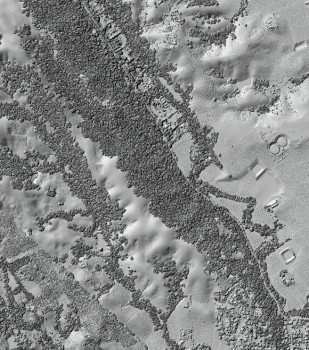
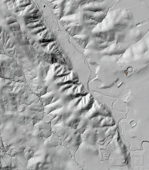
Highest-hit (left) and bare earth (right) DEM hillshade images showing linear trends typical of Quarternary faulting in the South Napa region
Thank you to the many organizations and partners who funded, collected, and processes the 2014 South Napa Earthquake data.
