Vertical differencing along San Diego coastline highlights areas of major coastal erosion
Monitoring the stability of the coastline in San Diego County, California is of significant interest given the number of cliff collapses in recent years and the high housing and infrastructure density along the coast. There is particular concern for the future, as climate change and rising sea levels are likely to accelerate coastal erosion.
At the very end of 2020, there was a bluff collapse within the Torrey Pines community in San Diego caught on video by beachgoers, a part of cliff collapsed in Del Mar in early 2021 near a stretch of train tracks, and in 2019 there was a fatal cliff collapse in Encinitas killing three. There were additional bluff collapses in Encinitas in August 2020 and May 2021.
The City of San Diego maintains a Coastal Erosion Assessment Program, and the Scripps Institution of Oceanography has a long running coastal cliff research program that recently received $2.5 million in funding to continue lidar surveys along the San Diego coast and work to establish a future alert system.
The existing multi-temporal lidar coverage of the San Diego County coastline provides a means to identify areas of coastal erosion and to quantify rates of coastal change. Vertical differencing of multi-temporal lidar topography provides a way to detect changes in coastal features. Vertical differencing subtracts gridded elevation data spanning a time period of interest to show how the landscape has changed over time.
We used USGS 3D Elevation Program (3DEP) lidar topography that was acquired in March 2006 and April–May 2016 to calculate the vertical difference of the San Diego County coastline spanning ~65 km from San Diego north to Oceanside. These results provide insight into how the coastline has changed in the span of a decade, extending the temporal span of lidar analysis in Young (2018).
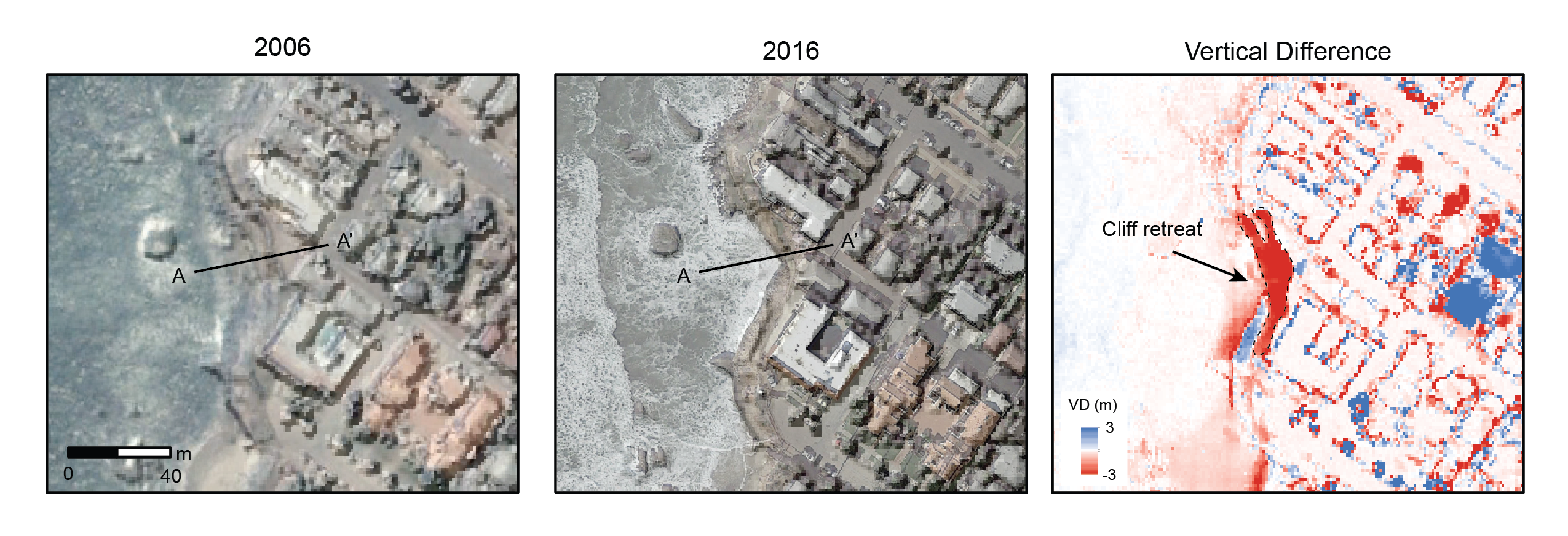
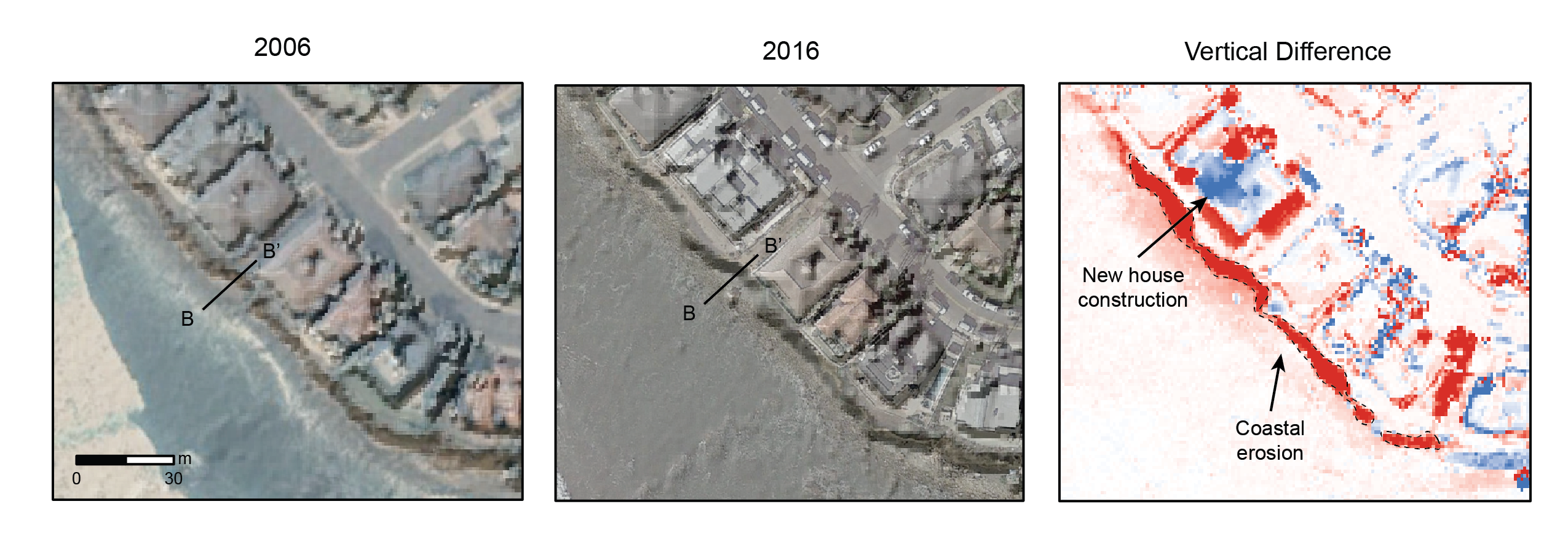
In the vertical differencing plots below, red indicates where the surface has shifted downward, and blue indicates where the surface has shifted upward. We use digital surface models (DSMs), which represent the natural and built surface environments. Surface changes may be the result of new construction, vegetation growth or clearing, or coastal erosion or deposition. Areas of deep red along the coastline highlight where significant erosion has occurred.
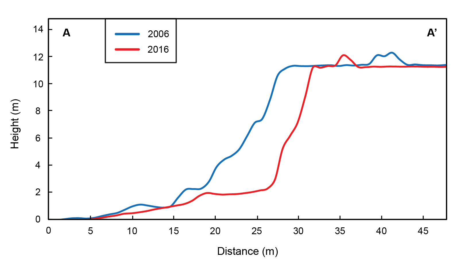
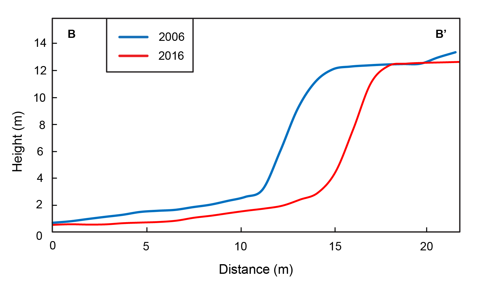
The examples below show hillshades overlain on imagery acquired from Google Earth for both 2006 and 2016 and the resulting vertical difference plot, in addition to topographic profiles of the coast from 2006 and 2016.
Near Bermuda Beach, Sunset Cliffs, San Diego
This first example shows an area of significant coastal erosion and retreat near Bermuda Beach in the Sunset Cliffs area of San Diego. The bright concentrated red in the vertical difference plot along the coastline highlights an area of significant erosion, where the land surface has moved down due to cliff collapse and retreat. In comparing the topographic profiles of the cliff face from 2006 and 2016 (A to A’), the cliff retreated back ~5 m. Within this ~400 m2 area, ~1420 m3 of material was eroded over the course of a decade.
False Point, La Jolla
This next example shows coastal erosion and cliff retreat along a ~140 m stretch of cliff face near False Point in southern La Jolla. The new housing construction in this view was built further away from the coast edge than was the previous existing structure. Across the topographic profile (B to B’), the cliff face retreated back ~3.5 m in ten years. Along this stretch of coast, ~2370 m3 of material was eroded over a decade.
Tide Beach Park, Solana Beach
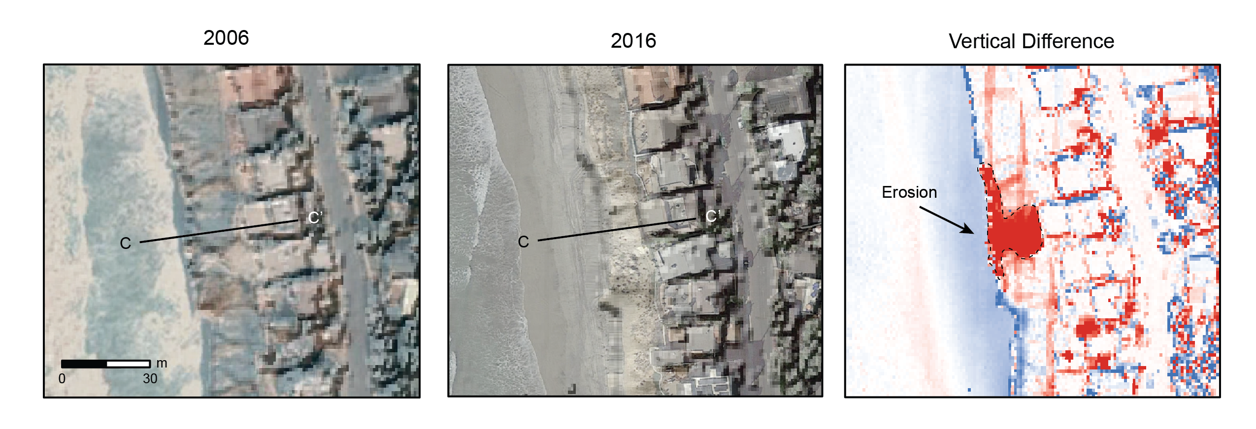
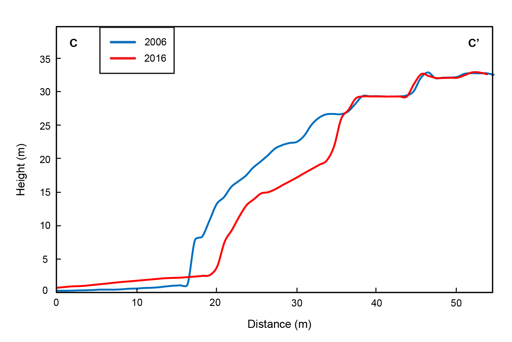
This final example near Tide Beach Park in Solana Beach shows a large erosional slump along the coast. ~1480 m3 of material was eroded from a ~320 m2 area over a decade. The base of the cliff face here migrated back ~3 m (profile C to C’).
USGS 3DEP data is available via OpenTopography to the academic research and education community. Users with a .edu email address simply need to login or create an account and request access to 3DEP data. K-12 teachers, international academics, and informal educators can apply for access here.
Do you work in academia, government, or industry and are interesting in working with OpenTopography on topographic differencing? Get in touch with our team at info@opentopography.org.

