Report compares LiDAR to aerial and multi-spectral imagery for identifying and mapping active faults
Ante Perez at the California Geological Survey recently forwarded me a link to a Final Technical Report they've submitted on research conducted with funding from the USGS National Earthquake Hazards Reduction Program (NEHRP). The report, entitled Utility of Combined Aerial Photography and Digital Imagery for Fault Trace Mapping in Diverse Terrain and Vegetation Regimes (project Co-PIs: Jerome A. Treiman, Florante G. Perez, and William A. Bryant, all CGS) compared various types of imagery for mapping and identifying active faults in southern California:
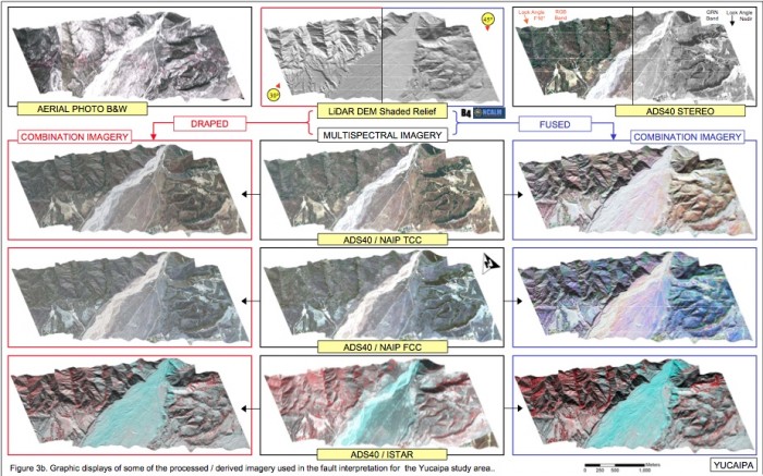
In this study we compared the effectiveness of shaded relief imagery derived from high-resolution LiDAR digital elevation models to standard aerial photography and to digital multi-spectral imagery for identifying and mapping active faults in moderate to sparsely vegetated terrain in southern California. The digital imagery included recently acquired digital stereo imagery. We also compared LiDAR-derived imagery to several combinations of draped or fused digital imagery. Additionally, we looked at the use of accurately georeferenced digital imagery for the accurate registration of interpreted data from older non-registered aerial photography. The study areas spanned varying terrain and geology.
The report is quite comprehensive and offers a nice comparison of the advantages and disadvantages of the various types of imagery. There are also many nice figures that show comparisons of imagery for a single study site, as well as fusions of the the imagery layers.

Among the report's conclusions is that in areas of relatively sparse vegetation, the LiDAR data is not as useful as imagery due in part to tonal variations that can not be scene in the grey scale LiDAR hillshades:
We found that no single type of imagery could serve as a stand-alone product for fault interpretation, as most image types added some value not found in other imagery. However, stereo imagery (photographic or digital) proved the most useful in the areas evaluated in this study. The lack of tonal distinctions in the LiDAR imagery was a detriment in areas where geomorphic expression was absent, although combination with spectral imagery compensated for this to some small degree.
The B4 LiDAR data used in this study were accessed and gridded using OpenTopography.
