The OT Bibliography: a review of publications using OpenTopography
As most OpenTopography users hopefully appreciate, primary support for OT comes from the U.S. National Science Foundation, and thus our primary emphasis is on facilitating access to topographic data oriented towards Earth science research. In the context of academic research, publications are perhaps the most important metric for measuring impact. As we prepare for a renewal proposal to the NSF for continued funding to support OpenTopography, we’ve endeavored to quantify how the open and easy access to high-resolution topography that OT offers has facilitated published research.
We performed a review of references to OpenTopography in the published literature using web-based searches of online journal databases. We also compiled feedback from the 2015 OpenTopography user survey. Since 2006, we found 140 peer reviewed publications, 23 M.S. and PhD theses, and 25 reports or position papers that utilized OpenTopography resources including data and processing tools.

Publications since 2006.
OpenTopography’s roots began in 2004 with Geoscience Network (GEON) project. GEON was designed to bridge cultural and disciplinary boundaries to bring together Earth and computer science experts for the common goal of developing the next generation of Earth science tools. One of the products of the project was the GEON lidar workflow, which sought to improve scientific access to lidar point cloud data. Simultaneously, lidar data were being recognized as revolutionary in the Earth sciences, and specifically in the active tectonics community. From the start, several important datasets focused on active faults were collected and remain important today including the B4 lidar project and the GeoEarthScope collection. Publications using those data drove early productivity from OT.
Digital Object Identifiers (DOIs)
Publications using OpenTopography data are on an upward trend and follow similar increases in available data and registered users. One way that we identify publications utilizing OT data is through Digital Object Identifiers, or DOIs. A DOI is a unique alphanumeric string, assigned by a registration agency to identify digital content and provide a persistent link to its location. DOIs have become a standard for identifying, sharing, and tracking digital publications, documents, and data. OpenTopography issues a DOI for each dataset we host via the University of California’s Digital Libraries EZID program. When an OpenTopography dataset is utilized in a publication or other product, the dataset should be cited, and DOI should be included. This data citation allows readers to directly link back to the data products, metadata, and other information, and ensures that the original researchers, funding agencies, and other involved in the collection of the dataset receive appropriate credit. The Earth Science Information Partnership (ESIP) maintains recommendations for best practices in data citation here if you’d like more information on how to properly cite data in your future publications: http://wiki.esipfed.org/index.php/Interagency_Data_Stewardship/Citations/provider_guidelines
Publication Trends
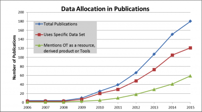
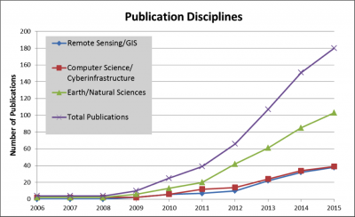
Looking at peer-reviewed publications, a clear rising trend is evident since OpenTopography started. While the acknowledgement of OpenTopography as a resource has increased, the number of publications that mention and use a specific dataset has also increased steadily since 2010. As would be expected given our focus and funding, the dominant discipline that references OpenTopography in publications is the Earth and natural sciences, but the number of remote sensing and computer science (e.g., cyberinfrastructure, algorithm development) papers are also steadily increasing. In addition, OpenTopography is also cited as a resource for urban planning and development, 3D game development, and 3D printing.

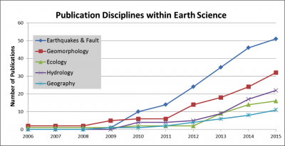
OpenTopography started with several active faulting and earth science based datasets.
OpenTopography continues to be a valuable asset to the Earth science community, serving data that are useful for quantifying and analyzing surfaces, vegetation, hydrological features, and infrastructure. An emerging research area is in the analysis of spatially overlapping and temporally separate datasets to quantify landscape change. Researchers in natural hazards have benefited from repeat lidar data in order to capture specific events like landslides and earthquakes. Notably, two earthquakes (2010 El Mayor Cucapah, and 2014 South Napa) have been captured by repeat lidar and have allowed researchers to make observations about along fault behaviors and subtle deformation patterns not visible with radar satellites.

Earthquakes and fault studies have been a staple of the science using OpenTopography data, but the applications broaden with more communities accessing and publishing using lidar data from OpenTopography.
We are very excited to see these results but recognize that we may be missing some publications. If you’ve published research that utilized OpenTopography, please take a moment to review the OpenTopography Community Bibliography and make sure that we’ve included your work. If not please let us know and we will update our records.
Update: most recent version of OT bibliography (7/26/2015)
