NOAA-Funded Project Mapping Offshore San Andreas Fault
A NOAA expedition that concluded this past Sunday focused on mapping the offshore extent of the San Andreas fault at high-resolution. Using sonar mapping and other imaging and geophysical technologies, the NOAA-funded group, led by Chris Goldfinger from Oregon State University, is building a 3D model of the fault that they hope will reveal information about earthquake behavior as well as the role of the fault in undersea life:
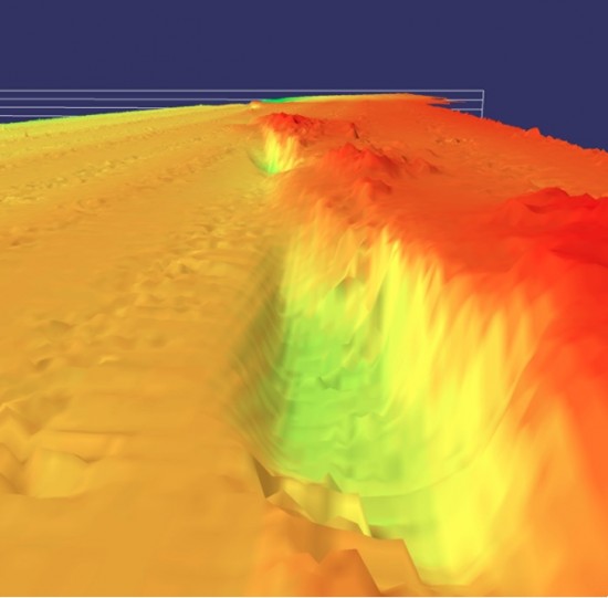
While the fault on land is obscured by erosion, vegetation and urbanization in many places, scientists expect the subsea portion of the fault to include deep rifts and high walls, along with areas supporting animal life. The expedition team is using high-resolution sonar mapping, subsurface seismic data and imaging with digital cameras for the first-ever three-dimensional bathymetric-structural map that will model the undersea Northern San Andreas Fault and its structure. Little is known about the offshore fault due to perennial bad weather that has limited scientific investigations.
Combined with the existing high-resolution topography data collected along the San Andreas by the EarthScope project (and an earlier NASA/USGS funded project), there will now be a high-resolution model of fault geomorphology for the full length of the San Andreas, from near the Mexican border in Southern California, to the fault's northern terminus at the Mendocino Triple Junction offshore Northern California.
More information: "NOAA-Sponsored Scientists First to Map Offshore San Andreas Fault and Associated Ecosystems"

Image via NOAA press release: "Image courtesy of San Andreas Fault 2010 Expedition, NOAA-OER" Caption: "This image shows the subsurface San Andreas Fault, approximately eight miles offshore Fort Bragg, Calif. The fault scarp, or step-like feature is 30-50 meters high. The depressions shown next to it, called "sag ponds" on land, result from small changes in the trend of the fault."
