Students use OpenTopography to evaluate how well mapping of Earth’s surface features can predict earthquake surface rupture
By Emily Zawacki
In regions with a high earthquake hazard, determining where and how Earth’s surface may move and break in an earthquake is crucial in hazard analysis and risk mitigation. While certain regulations may prohibit structures from being built along or near active faults, not all faults are known, and some structures may be required to cross faults, putting them at risk from displacement at Earth’s surface.
Traditionally, geologists use clues and features on Earth’s surface that are indicative of past earthquake activity to map and determine where Earth’s surface may break in a future earthquake. However, such indicative features may not be well preserved on the surface, and the ground may break in unexpected places during an earthquake.
A new open access study published in Geosphere led by OpenTopography team member Dr. Chelsea Scott evaluates how well mapping based on Earth’s surface features could predict where the ground would rupture and move in a future earthquake. In the Mapping Active Faults course taught collaboratively between Arizona State University and the University of Nevada–Reno, geoscience students learned techniques for mapping tectonic faults in different geomorphic and tectonic environments.
The students learned about using and interpreting remote sensing data, including topography and satellite imagery. They used QGIS to make topographic derivatives such as hillshades and produce linework showing the mapped faults. Because the fault mapping class was held Fall 2020 during the global Covid-19 pandemic, the course had to be remote. This fact facilitated collaboration between the two universities, as well as for industry and government geologists to discuss their work and perspectives from outside of academia.
Students used topography data from OpenTopography and satellite imagery collected before earthquakes in Idaho (US), California (US), Baja California (Mexico), Japan, and New Zealand. The students identified features at Earth’s surface that were likely formed by past earthquake activity and mapped the location of faults.
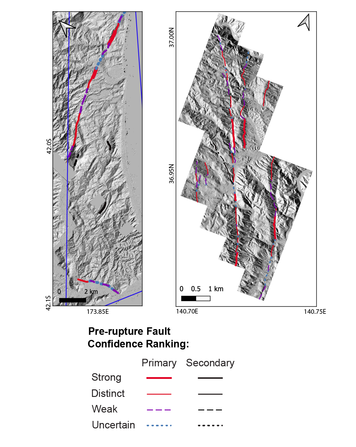
The students’ maps were compared to where the ground actually ruptured in the earthquakes to evaluate how well the maps predicted where an earthquake would break the ground. The student maps predicted between 12% to 68% of the main surface breaks from the earthquakes. For some earthquakes, the student maps were better able to predict the primary rupture rather than more distributed ruptures. Overall, the student maps were better at predicting the ruptures of the more recent earthquakes, which had higher quality data available.

Predictive pre-rupture fault maps of the 2016 M 7.8 Kaikoura, New Zealand, earthquake (left) and the 2011 M 6.6 Fukushima-Hamadori, Japan, earthquake (right) based on indicative surface features. Image credit: Dr. Chelsea Scott.
While the students’ maps showed some errors and misinterpretation of surface features, the student maps provide insight on the uncertainty of fault locations and common mapping errors, and demonstrate that students can gain mapping skills and produce high quality fault maps through careful teaching.
“Everything in this class was new to me. The combination of learning and understanding all of these topography datasets and fault mapping at once was a difficult and rewarding process. I was not sure what a geology course would look like during the pandemic, but the nature of the class worked well being remote. It gave me tools and knowledge that I continue to use today,” said Joe Powell, an Arizona State University master’s student who took the fault mapping course as an undergraduate.
Rachel Adam, a master’s student at Arizona State University who also took the course as an undergraduate said, “The class was one of my first experiences working with remote sensing datasets and fault mapping. The course enriched my knowledge and provided me tools that I will be able to use beyond academia. Having access to a database [OpenTopography] that houses a multitude of open-source, high quality data was something I was not aware of prior to taking the course, and it is something I continue to use in the years since the class concluded.”
Dr. Scott, lead author of the study and one of the course instructors noted, “The students provided critical insight into the project, because unlike most professional geologists, the students had no knowledge of the ruptures associated with these earthquakes. This allowed us to produce fault maps with remote sensing data acquired before well known earthquakes without knowledge of the future rupture location.”
“This study showed that mapping tectonic faults is an under-appreciated challenge in fault displacement hazard. The uncertainty in fault location from this study has important implications for assessing the hazard and risk posed by faults,” said Scott. “These values inform the development of fault uncertainty zones for displacement hazard applications as well as the accuracy of regional mapping that supports subsequent work on site evaluations, regulatory zoning, and paleoseismic trenching for scientific research.”
- Publication: Scott, C., Adam, R., Arrowsmith, R., Madugo, C., Powell, J., Ford, J., Gray, B., Koehler, R., Thompson, S., Sarmiento, A., Dawson, T., Kottke, A., Young, E., Williams, A., Kozaci, O., Oskin, M., Burgette, R., Streig, A., Seitz, G., Page, W., Badin, C., Carnes, L., Giblin, J., McNeil, J., Graham, J., Chupik, D., and Ingersoll, S., (2023). Evaluating how well active fault mapping predicts earthquake surface-rupture locations. Geosphere, https://doi.org/10.1130/GES02611.1.
