Interpreting Errors in Topographic Differencing Results
By Chelsea Scott & Chris Crosby
Topographic differencing measures landscape change from a variety of natural and anthropogenic processes including urban growth, flooding, coastal erosion, earthquakes, volcanic eruptions, and landslides. Interest in differencing continues to grow as more areas are covered by multi-temporal topography datasets (i.e., two or more topography datasets at the same location), thanks in part to efforts to collect national-scale data like the US Geological Survey’s 3D Elevation Program (3DEP). However, differencing results must be interpreted with care to ensure that sources of noise are not confused with real signals of landscape change.
Vertical differencing is the subtraction of grid-based digital elevation models (DEMs). Because topographic differencing quantifies changes to the landscape that are often of a similar magnitude to the errors in the source topography data, topographic differencing tends to accentuate errors in the input datasets. Below, we discuss four examples of common errors in vertical topographic differencing, illustrating cases where the apparent change largely reflects noise and not true landscape change.
Topographically Correlated Apparent Change due to Georeferencing Errors
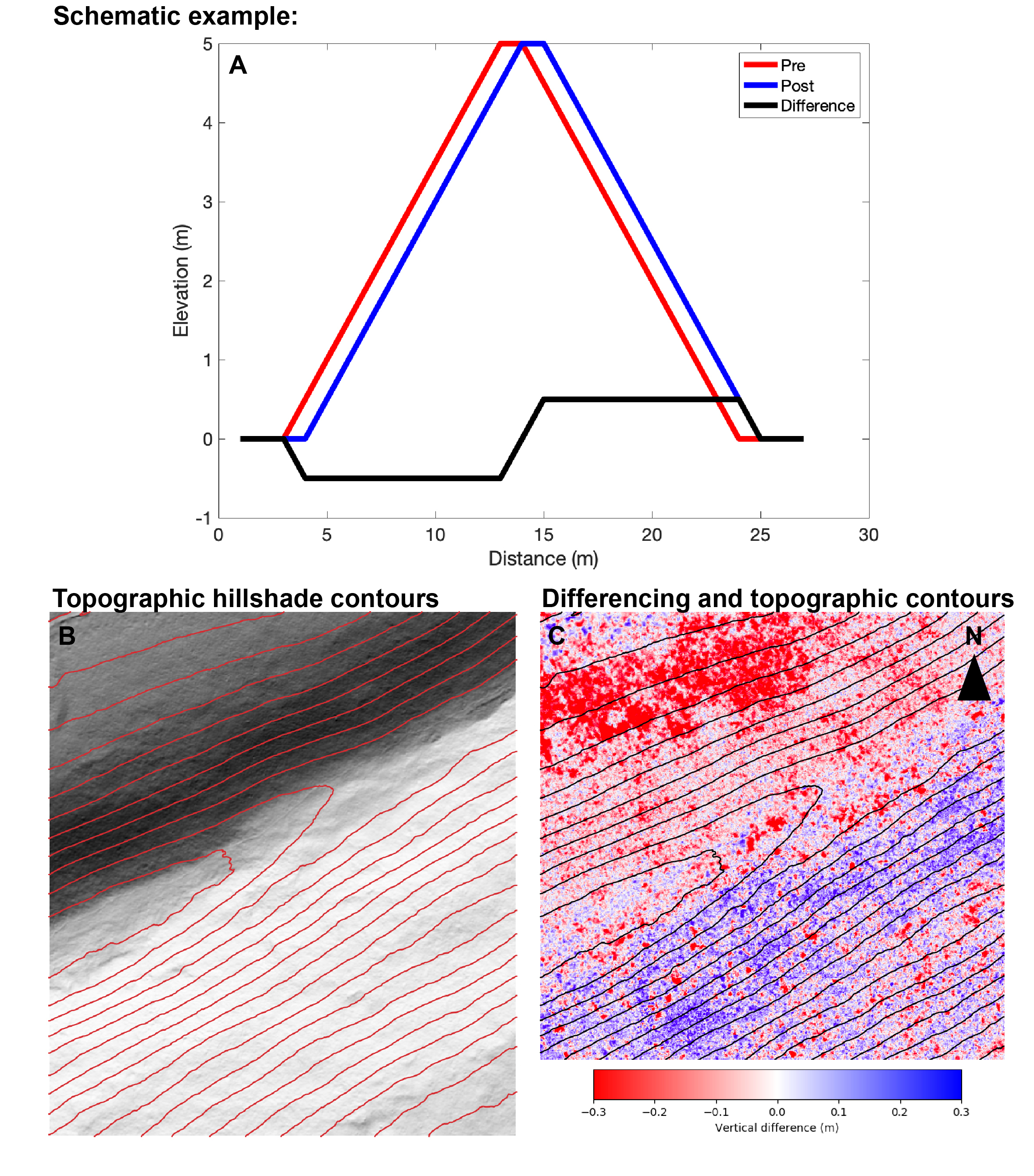
Accurate vertical differencing results require that the topography datasets are well-aligned, or in other words, are correctly georeferenced. When horizontal georeferencing errors are present, a topographic feature in one dataset is offset from itself in the other dataset. This is shown in the schematic example below where the topographic peak is mapped at different locations in the pre- and post-event dataset due to a georeferencing error. The differencing results show apparent vertical deformation that correlates with the direction of the topographic slope. In the schematic example, the left side of the peak shows apparent subsidence or deposition, and the right side shows apparent uplift or erosion. A similar error is seen in the vertical differencing of topography displaced by strike-slip earthquakes where the lateral shift due to the coseismic offset results in datasets that are no longer coregistered, and these horizontal offsets appears as vertical topographically correlated artifacts.
This type of error is illustrated in the example below surrounding a ridge in the Susquehanna Shale Hills in central Pennsylvania. To the northwest of the ridge, the surface appears to have moved downward, while to the southeast of the ridge, the surface appears to move upward.

(A) Schematic illustration of topographically correlated differencing errors created by georeferencing errors in the pre- and/or post-event topography datasets. The pre-event topography (red) is horizontally misaligned or shifted from the post-event topography (blue). B: Example of topographically correlated errors from differencing topography along a ridge in the Susquehanna Shale Hills of central Pennsylvania. The topographic hillshade (B) shows red contour lines. The blue (in the southeast) and red (northwest) colors in the differencing results (C) reflect topographically correlated noise from georeferencing errors and not true ground displacement.
Stripes From Flight Alignment Errors
Airborne lidar surveys are typically conducted along multiple parallel and overlapping paths or flight-lines. Offsets of the topography collected along adjacent flight-lines due to georeferencing errors create apparent vertical offsets that manifest as linear, swath-to-swath artifacts in the differencing results aligned with the flight direction. The resulting stripes do not represent real topographic change. These flight-line misalignments are often on the order of a few tens of centimeters (or less) and can interfere with interpreting smaller and especially linear patterns of surface change. The example below shows fluvial activity along the Wabash River in southwestern Indiana. The north-south oriented stripes in the right panel (C) reflect flight-line errors and make it challenging to distinguish between erosion (typically red) and deposition (typically blue).

Topographic differencing results along the Wabash River, Southwestern Indiana. The north-south stripes in the right panel (C) are noise and reflect flight alignment errors, not true vertical deformation or change. See Scott et al., (2022) for additional discussion and examples.
Tens of Meters of Apparent Deformation Due to an Incorrect Vertical Datum
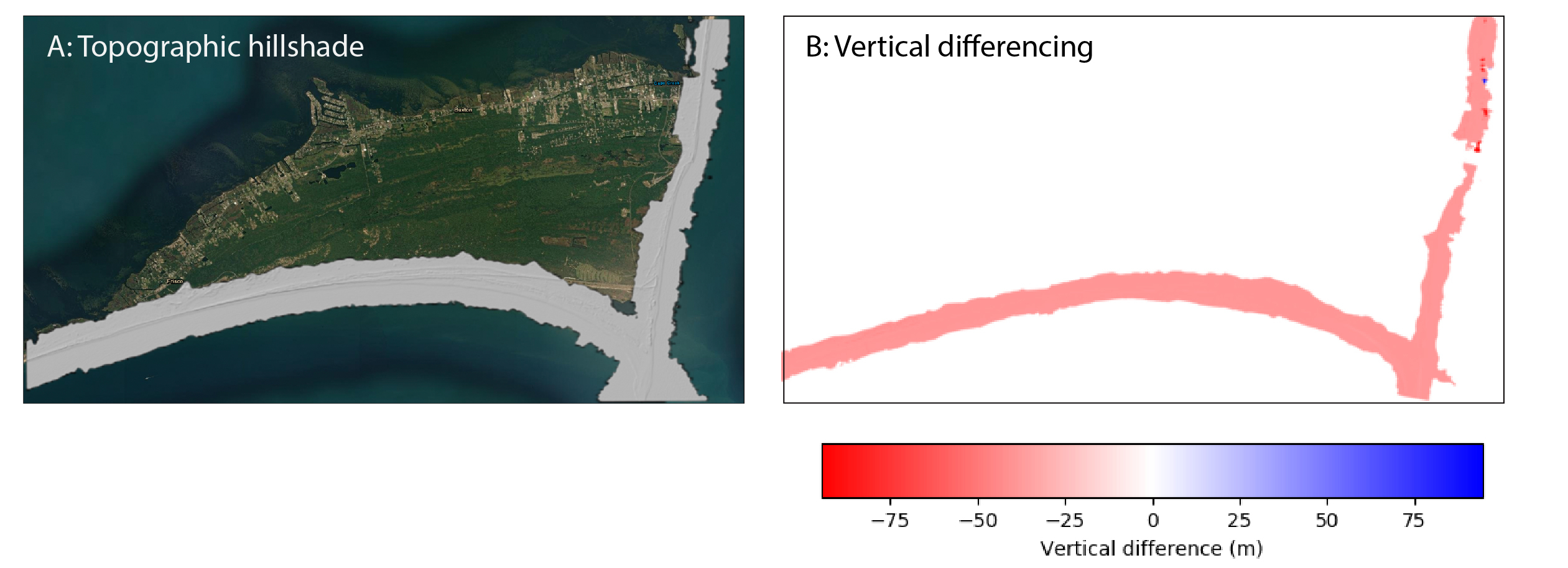
Accurate differencing requires that both datasets are in the same vertical and horizontal coordinate reference system. OpenTopography makes a best effort to ensure that coordinate systems are aligned before initiating differencing of datasets, however, metadata can sometimes be incorrect, leading to errors. Below is an example of differencing results in the Outer Banks of North Carolina that suggest a vertical change of 40 m between 2006 and 2007. Systematic apparent vertical changes on the scale of a few tens of meters over the entire dataset are typically due to datasets that are referenced to different vertical datums. Most commonly, one dataset is in orthometric height (aka "height above sea level") while the other is referenced to the ellipsoid. In this North Carolina case, both datasets are reported to be in orthometric heights, although the differencing results suggests that one of the datasets is actually in ellipsoidal height.

Outer Banks, North Carolina: (Left) Topographic hillshade spanning the southern and eastern coast of the island. The ~40 m apparent vertical change (right) reflects errors in the reported metadata and the vertical coordinate reference system, not actual vertical change.
Mis- or Inconsistent Classification of Ground Points and Digital Terrain Models Errors
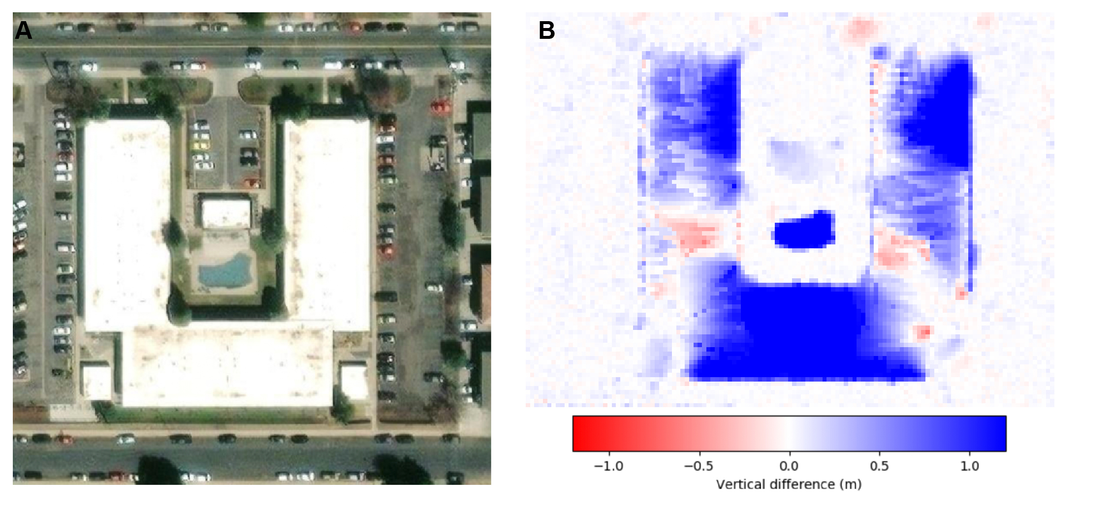
Differencing digital terrain models (DTMs) shows how the shape of the bare earth changes over time. Accurate generation of DTMs requires that the lidar point cloud data are correctly classified to differentiate ground points from other features such as buildings and vegetation. Sometimes the ground is incorrectly or inconsistently classified, leading to different models of the ground surface. This can especially be true around building where there are no ground points to constrain the DTM. The difference map below shows results from June to August 2010 in Boulder, Colorado. Here, much of the apartment building appears to move up by almost a meter. This should be flagged immediately as a likely error due to the common challenges of producing a DTM surrounding buildings and that the apparent meter change is not large enough to represent the construction of a new building. This type of error can be confirmed by viewing images acquired at different dates using a tool like Google Earth's Historical Imagery slider.

Apparent DTM change at a building in Boulder, Colorado: (A) Image of an apartment complex. (B) Apparent change of 1 m reflects classification and interpolation errors in one or both DTMs used in the differencing.
Interested in learning more about topographic differencing? See our topographic differencing resources with video tutorials, blog posts with differencing examples, workshop presentations, links to GitHub code repositories, and a differencing exercise designed for undergraduate courses.
