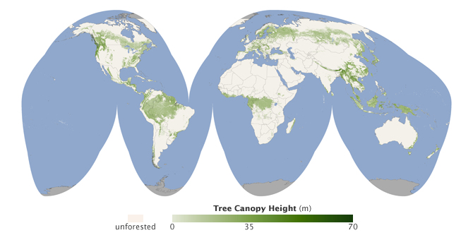
Global Forest Heights Map From NASA LIDAR and MODIS Data
A press release from NASA yesterday highlights the first global map of forest canopy heights created from ICESat LiDAR and MODIS data. The map, produced by Dr. Michael Lefsky at Colorado State University, is the first of its kind generated with a uniform methodology and has important applications for developing global carbon budgets. Specifically, the map "will help scientists build an inventory of how much carbon the world's forests store and how fast that carbon cycles through ecosystems and back into the atmosphere".

The global ICESat LiDAR coverage allows this kind of comprehensive mapping of the forest height globally:
Lidar can capture vertical slices of forest canopy height by shooting pulses of light at the ground and observing how much longer it takes for light to bounce back from the surface than from the top of the forest canopy. Since lidar can penetrate the top layer of forest canopy, it provides a detailed snapshot of the vertical structure of a forest.
"Lidar is unparalleled for this type of measurement," Lefsky said. "It would have taken weeks or more to collect the same amount of data in the field by counting and measuring tree trunks that lidar can capture in seconds."
OpenTopography and partners from UNAVCO and the National Snow and Ice Data Center have funding from NASA to provide integrated access to existing NASA LiDAR data products from ICESat and LVIS, as well as on-demand processing capability, and enhanced QA/QC metrics to make these data more easily accessible and usable to a range of scientists. Once implemented, access to these data will be available through the OpenTopography Portal. Read more about the NASA LiDAR Access System (NLAS) project.
