OpenTopography computes first map of topographic change at the statewide scale
The OpenTopography team is pleased to announce the publication of our new open-access article in the journal Remote Sensing: “Statewide USGS 3DEP Lidar Topographic Differencing Applied to Indiana, USA.”
In this study, we produced the first ever map of statewide high-resolution topographic change and canopy height models of Indiana. Topographic differencing of multi-temporal topographic data is a powerful technique used to measure natural and anthropogenic change at the Earth’s surface. The differencing results show change from a variety of processes related to the agricultural, forest, river, urban, and coastal environments of Indiana. We selected Indiana for this differencing study due to two available statewide lidar datasets and the ongoing partnership for data hosting between OpenTopography and the state of Indiana. We performed differencing using the 2011–2013 and 2016–2020 Indiana statewide lidar acquisitions, illustrating approximately decadal change to both the bare earth topography as well as vegetation and the built environment.
The results of this study are available as an easy-to-explore web map that provides a full visualization of the statewide topographic change results.
For this work, we used data from the US Geological Survey’s 3D Elevation Program (3DEP), which is an ambitious effort to collect high-resolution topographic data covering the US by 2023. The 3DEP data provides an immense opportunity to expand topographic differencing to the state and even national scale.
To produce the differencing maps, we solved several big data cyberinfrastructure challenges including accessing and managing very large data volumes, scaling compute resources for processing, and addressing inconsistencies and noise in the data from the different lidar acquisitions. Processing of data was run on dedicated OpenTopography servers at the San Diego Supercomputer Center at UC San Diego.
- Research Article: Scott, Chelsea P., Matthew Beckley, Minh Phan, Emily Zawacki, Christopher Crosby, Viswanath Nandigam, and Ramon Arrowsmith (2022). Statewide USGS 3DEP Lidar Topographic Differencing Applied to Indiana, USA. Remote Sensing, 14 (4), 847. https://doi.org/10.3390/rs14040847.
San Diego Supercomputer Center press release about this work: Researchers Produce First Map of Topographic Change at Statewide Scale

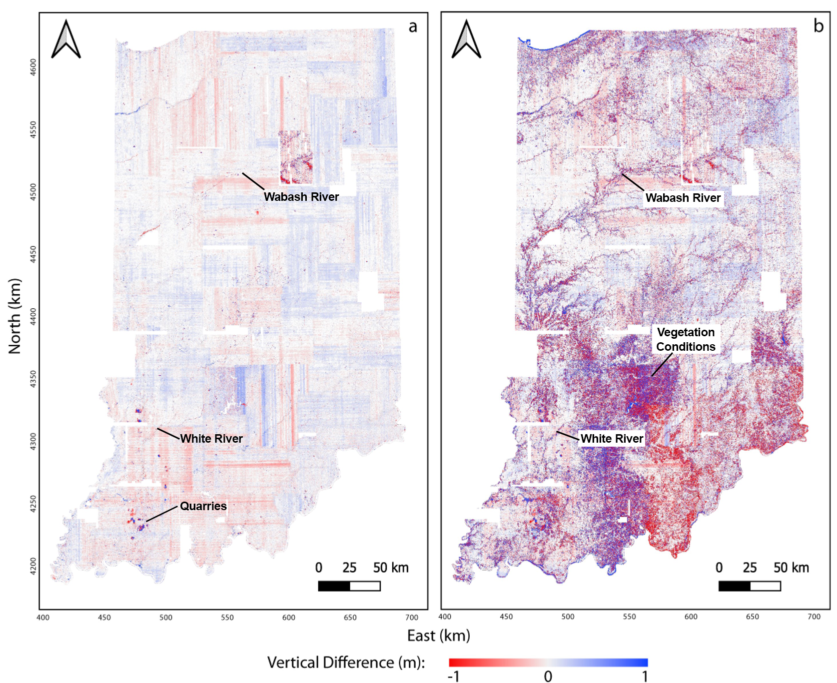
Indiana statewide topographic differencing with high resolution lidar topography collected in 2011–2013 and 2016–2020. (a) The differenced digital terrain model (DTM) and (b) the differenced digital surface model (DSM). Both the differenced DTM and DSM reflect physical changes due to mining and quarrying near the western and southern state borders. The Wabash River and the White River create change patterns stretching across the central and southern portions of the state produced by fluvial, riparian, and anthropogenic activity. Color variations in the south-central portion of the DSM change map reflect different seasons of lidar acquisitions and leaf-on and off conditions. The distinct north-south and east-west oriented lines primarily seen in the DTM do not represent change and are an error artifact from the lidar data.

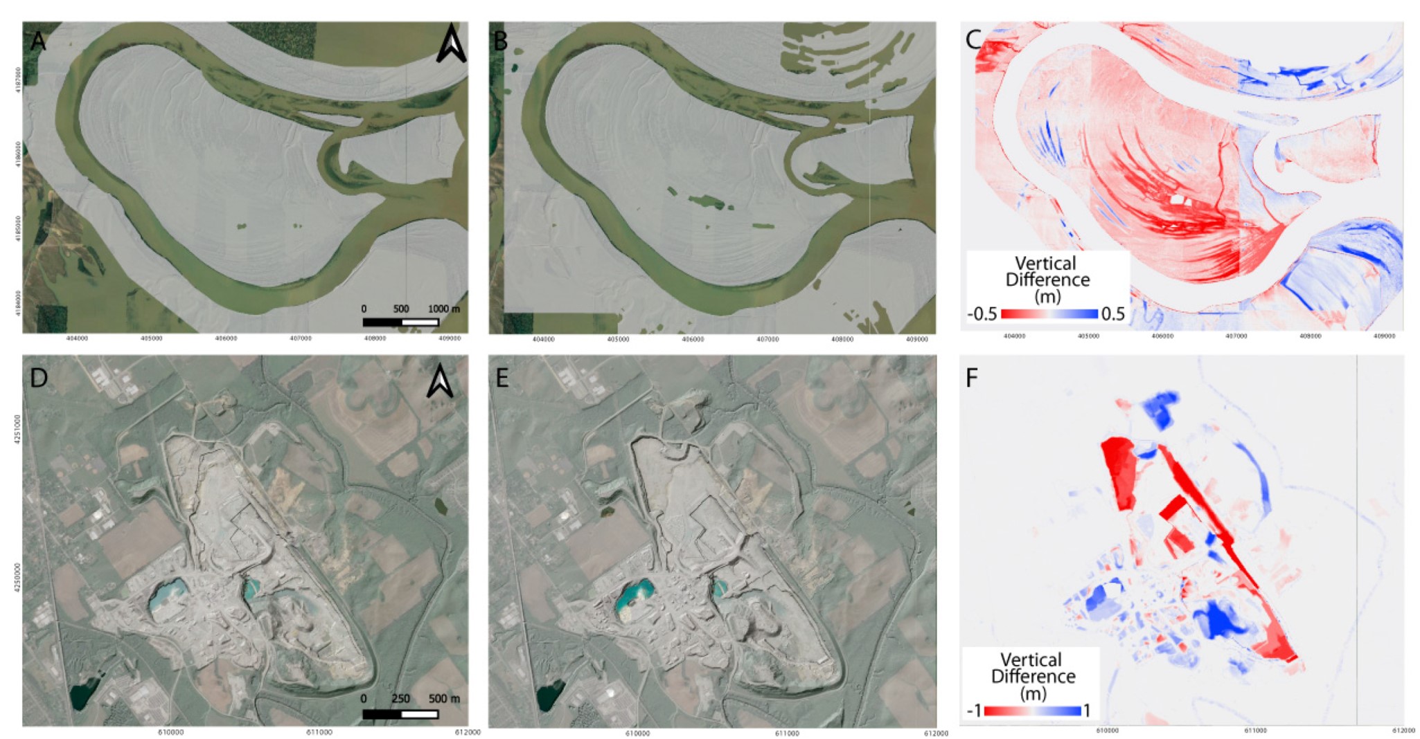
(A–C) Wabash River fluvial change along point bar scrolls in SW Indiana, (D–F) Sellersburg Stone Quarry excavation and piles near Louisville, IN, highlighted on the differenced digital terrain models.

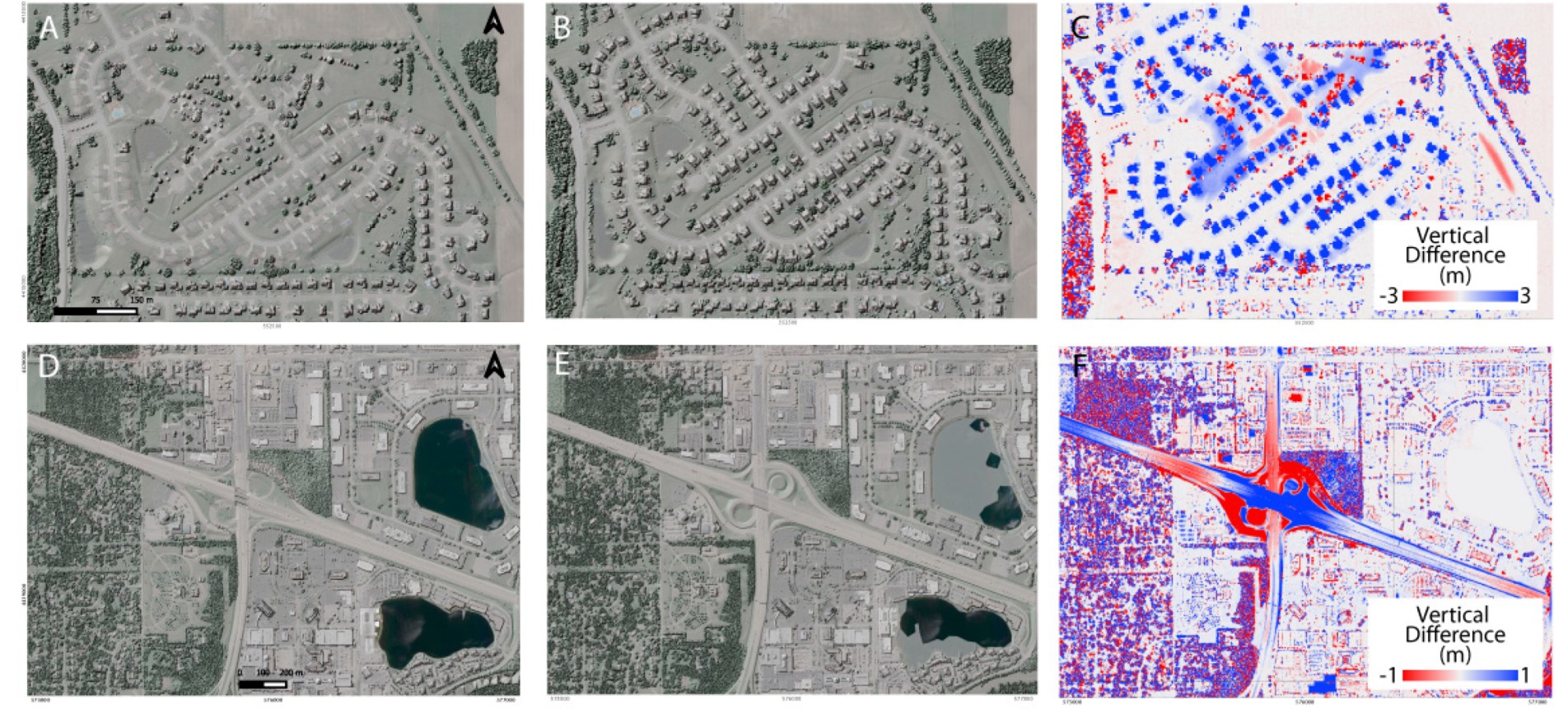
(A–C) A new housing development and (D–F) highway construction near Indianapolis, highlighted on the differenced digital surface models.
