USGS LiDAR Funding Opportunity
Last week the USGS released its much anticipated LiDAR and Orthoimagery RFP. The ARRA (American Recovery and Reinvestment Act of 2009) funded RFP will award 15 grants of up to $500,000 each for the "collection and processing of high resolution elevation data and orthoimagery". The grant is only open to institutions of higher education and state, local and Indian tribal governments. Federal agencies and the private sector are not eligible.
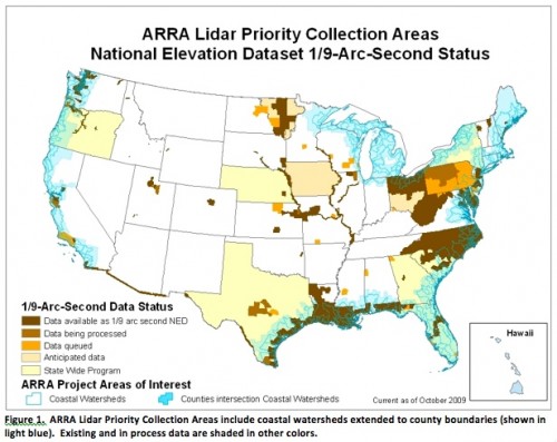
Priorities for the grant are relatively specific with a focus on coastal portions of the country: "Priorities for the program include collecting elevation data over those coastal areas of United States most susceptible to storm and hurricane flooding, earthquake damage, and coastal erosion". All data collected by organizations funded via this grant will ultimately be ingested into the USGS National Elevation Dataset (NED) to expand the extent of available 1/9 arc second (roughly 3 meter) topography data. The announcement also specifies that all raw LiDAR point cloud data will be added to the archive maintained by the USGS Center for LIDAR Information Coordination and Knowledge (CLICK). The announcement includes the following map, which shows the regions of the country that are deemed highest priority for ARRA topography funds. The map also shows the extent and status of 1/9 arc second topography in NED - most of which is data derived from state, local and federal LiDAR data collections - and may therefore be interesting for folks curious about where LiDAR data may be available in their region or area of research. Regional, zoomed views, of the map below can be downloaded as a supplement to the grant announcement.

Although this grant is an exciting opportunity to acquire a significant amount of new LiDAR data, there has been significant debate about the quality of the data specified by the RFP. The grant announcement specifies "high resolution (1 point per square meter (ppsm)) lidar", which is significantly lower resolution than the 6-8+ shots per square meter data that is being delivered by projects such as the EarthScope (data hosted here on OpenTopography), and the Oregon and Puget Sound LiDAR Consortia. Therefore, there is concern that these USGS-funded data will be of less utility to Earth science researchers, especially in areas of steep terrain and dense vegetation.
