OpenTopography Completes Ingestion of all NCALM Lidar Data Collected Between 2003 & 2012
OpenTopography is pleased to announce that we've completed our work to ingest and provide open access to all National Science Foundation funded lidar datasets collected by the National Center for Airborne Laser Mapping (NCALM) between 2003 - 2012. In total, there are now 116 NCALM point cloud lidar datasets available via OpenTopography - greater than 126 billion lidar points over more than 22,000 km2 of North America. Public and open access to this rich catalog of high-resolution topography data represents an outstanding and unprecedented opportunity to explore various landscapes and geologically and ecologically interesting areas in high-resolution three-dimensional data.
The release of these data via OpenTopography (OT) is the product of a memorandum of understanding between OpenTopography and NCALM to make OT the primary distribution pathway for NCALM data. Over the past year and a half, OT has worked systematically to validate and ingest these previously unavailable lidar point cloud datasets.
NCALM is a NSF-funded center that supports the use of airborne laser mapping technology (a.k.a. lidar) in the scientific community and is jointly operated by the Department of Civil & Environmental Engineering, Cullen College of Engineering, University of Houston and the Department of Earth and Planetary Science, University of California, Berkeley. Many of these datasets were collected under NCALM's graduate student seed proposal program that awards ten projects per year to graduate student PIs who need lidar data for their research. Each collection is typically limited to no more than 40 square kilometers.
OpenTopography is an Internet-based project that provides open and free access to high-resolution topographic data collected by technologies such as LiDAR (Light Detection and Ranging). OpenTopography is managed by the San Diego Supercomputer Center (SDSC) at the University of California, San Diego, and Arizona State University's (ASU) School of Earth and Space Exploration with funding from the National Science Foundation's Geoinformatics and Earth Sciences: Instrumentation and Facilities (EAR-IF) programs.
OpenTopography NCALM Data Statistics
- Number of datasets: 116
- Total Area covered: 22,464 km2
- Total number of LiDAR returns: 126,313,774,883
- Size on disk: 2,936 GB
- Number of States: 33
Plot showing OpenTopography ingestion of NCALM data per quarter since the project's initiation in 2008. OT's MOU with NCALM began Fall 2011, leading to a huge increase in online and publicly accessible lidar point cloud data collected with NSF funding.
The final NCALM dataset is a repeat survey of the Flathead Lake Biological Station, Northwestern Montana flown in May and September of 2005. The point cloud data were used in combination with optical remotes sensing data, both airborne and satellite, to identify pixels within multispectral optical imagery that corresponded to various vegetation height elevations. Those pixels were then separately classified by vegetation type. Data was also used to conduct simple flood inundation modeling of the floodplain and in combination with measures of flow depth and velocity extracting water surface elevation from the lidar to map the spatial distribution of stream power.


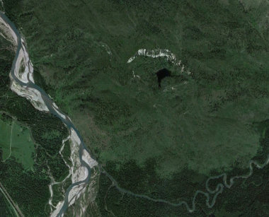
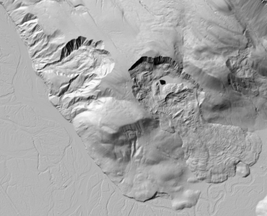
Google Earth imagery (top) and bare earth hillshade imagery (bottom) showing ancient landslides into the Middle Fork Flathead River Valley.
