Lidar Datasets from Virginia, California, Montana, Illinois, Oregon and Utah Available
We are pleased to announce the release several new datasets including new community contributed data from Virginia, updates to the existing Oregon Department of Geology and Mineral Industries (DOGAMI) dataset and nine new NCALM datasets from portions of California, Illinois, Montana and Utah. These data cover a wide range of geologic environments including Crater Lake National Park, Death Valley National Park, the Northern California Coast Range, Big Sky in Montana and Raplee Ridge Anticline in Utah. In addition to adding new data, the USGS CLICK (Center for LiDAR Information Coordination and Knowledge) layer on OpenTopography's find data map has been updated to reflect the current holdings.
Community Contributed Data:
Modeled after the OpenTopography Tool Registry, the OpenTopography Data Contribution module allows users to register metadata and spatial extent information about a lidar dataset hosted elsewhere. These community-contributed data will appear on the OT Find Data map and are discoverable by users alongside data hosted by OpenTopography and partners such as USGS. Recently added community data include portions Loudoun County and the City of Newport News, Virginia. Since July 2012 over 20,000 square kilometers of data have been added.
Crater Lake National Park, City of Ontario and Camp Creek Updates to Oregon Department of Geology and Mineral Industries Dataset:
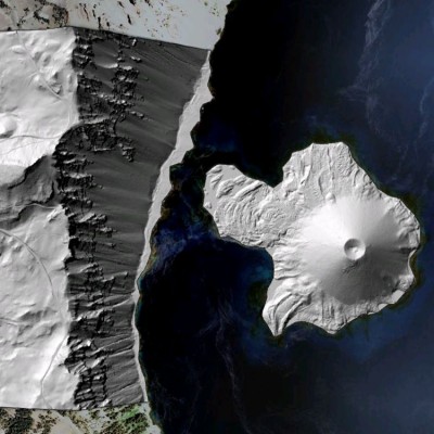
Data added to the DOGAMI dataset includes Crater Lake National Park, the city of Ontario on the Oregon/Idaho border and Camp Creek in Eastern Oregon. DOGAMI has been supervising and coordinating the collection of large swaths of high resolution, high accuracy lidar data in Oregon and adjacent states since 2006.


Hillshade images from Crater Lake National Park. (Left) bare-earth image of Wizard Island, (Right) avalanche track of Mt. Scott
National Center for Airborne Laser Mapping (NCALM):
NCALM is an NSF-funded center that supports the use of airborne laser mapping technology (a.k.a. lidar) in the scientific community and is jointly operated by the Department of Civil & Environmental Engineering, Cullen College of Engineering, University of Houston and the Department of Earth and Planetary Science, University of California-Berkeley. Three of the nine datasets were collected under NCALM's graduate student seed proposal program that awards ten projects per year to graduate student PIs who need lidar data for their research. Each collection is typically limited to no more than 40 square kilometers. The release of these data via OpenTopography is the product of a memoranda of understanding (MOU) between OpenTopography and NCALM to make OT the primary distribution pathway for NCALM data.
- Eel River, CA: Landsliding and the Evolution of Mountainous Landscapes
- Tender Foot, MT: Hydrological Processes on Hill Slopes
- Big Sky, MT: Patterns of Nitrogen Export & Land Use Change
- Furnace Creek Wash, Death Valley National Park, California
- Dragons Back Ridge: San Andreas Fault, California
- Sierra National Forest, CA: Soil Formation and Transport
- Lawrenceville, IL: Detecting Tectonically Deformed Shorelines
- Furnace Creek and Fish Lake Valley Fault Zones, Death Valley National Park
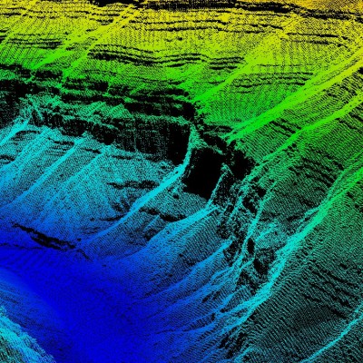
- Raplee Ridge, Utah

Point cloud image looking up the San Juan River from the Raplee Ridge, Utah dataset. Rock layering is characteristic of local geology and visible by black areas (no data) showing cliffs
