Deschutes and South Coast Oregon Lidar Datasets now Available
OpenTopography is pleased to announce the release of 1,556 km2 of lidar point cloud data covering the South Coast and Deschutes regions of Oregon. Totaling over 17 billion lidar returns, these data were collected through the Oregon Lidar Consortium supervised and coordinated by the Oregon Department of Geology and Mineral Industries (DOGAMI). All DOGAMI lidar data exceed 8 pulse/m2 and thus represent some of the highest resolution public domain lidar currently available.
OpenTopography have recently signed a memorandum of understanding with DOGAMI to begin hosting lidar point cloud data collected through the Oregon consortium. As this relationship moves forward, more of the over 17,500 mi2 of Oregon lidar data collected by DOGAMI will begin to appear in OpenTopography.

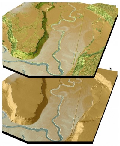
Image courtesy Watershed Science Inc.: "The Crooked River near Terrebonne, OR. Top image is derived from highest hit LiDAR, bottom image from bare earth LiDAR"
Background:
DOGAMI has been supervising and coordinating the collection of large swaths of high resolution, high accuracy lidar data in Oregon and adjacent states since 2006. Following a successful 2500 mi2 consortium effort in the Portland urban area, the Oregon legislature designated DOGAMI as the lead agency for lidar acquisition in Oregon. DOGAMI used a nationwide selection process that resulted in a state price agreement (OPA 8865) with Watershed Sciences Inc. of Corvallis, Oregon. The price agreement specifies data collection (8 pulse/m2, Zerror 2, and has taken final delivery of 16,000 mi2 of data. Funding for these projects has come from consortia organized by DOGAMI that include several dozen Federal, State and local government agencies, non-profits and public utilities. The data quality for all projects that DOGAMI has completed under OPA 8865 has been consistently excellent, substantially exceeding the minimum specifications. All DOGAMI lidar data is in the public domain, and DOGAMI as the data source.
