LiDAR for the Northeast Project Funded
A proposal for an extensive LiDAR collection of coastal regions of the Northeastern U.S. (New York, Connecticut, Rhode Island, Massachusetts, New Hampshire, and Maine) has been funded by the USGS with American Reinvestment and Recovery Act money. The proposal, led by the Maine Office of GIS, is to collect LiDAR data over ~13,500 square miles. MEGIS has an announcement about the funding. From the LiDAR for the Northeast proposal (PDF):
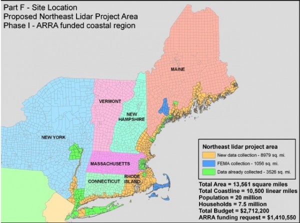
Full or partial county lidar collections for all coastal areas in New York, Connecticut, Rhode Island, Massachusetts, New Hampshire, and Maine, including many coastal watersheds and subwatersheds. The total area proposed is 13,561 square miles in a continuous swath with no gaps, including all coastal towns in the region, towns adjacent to major tidal rivers, and other adjacent areas deemed important to the stakeholders. Of this area, 8979 square miles is new data, 1056 square miles is being collected by FEMA, and 3526 square miles of other existing data (not in CLICK or NED). Only 58 sq. mi. of this entire region is currently in CLICK and only 410 sq. mi. are in the 1/9th arc-second NED
.
Map of the project area from the LiDAR for the Northeast proposal:

Data will be collected to the meet the recently released USGS-NGP Base LiDAR Specification, and thus will have 2m nominal point spacing. As is required by the ARRA LiDAR RFP, all of these data will eventually end up in the USGS CLICK archive and will be incorporated into the USGS 1/9 arc-second NED layer.
It appears that the proposal pulls together an impressive collection of federal and state agencies and non-profit organizations to build a consortium and generate matching funds. This looks like a great project and will produce a lot of new and valuable data.
